IMAGES TAKEN NEAR TO
Abbey Road, SANDBACH, CW11 3HB
Introduction
This page details the photographs taken nearby to Abbey Road, CW11 3HB by members of the Geograph project.
The Geograph project started in 2005 with the aim of publishing, organising and preserving representative images for every square kilometre of Great Britain, Ireland and the Isle of Man.

There are currently over 7.5m images from over14,400 individuals and you can help contribute to the project by visiting https://www.geograph.org.uk
Image Map
Images are licensed for reuse under creativecommons.org/licenses/by-sa/2.0
Notes
- Clicking on the map will re-center to the selected point.
- The higher the marker number, the further away the image location is from the centre of the postcode.
Image Listing (8 Images Found)
Images are licensed for reuse under creativecommons.org/licenses/by-sa/2.0
Image
Details
Distance
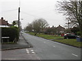
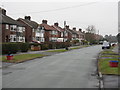
2
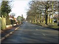
Elworth - Abbey Road
Lovely, tree-lined avenue.
Image: © Peter Whatley
Taken: 21 Jan 2011
0.11 miles

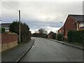
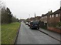
4
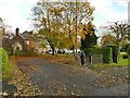
The east end of Proctors Lane
This is a no-through-road for motor traffic, but there is a cycle lane through to Hind Heath Road.
Image: © Stephen Craven
Taken: 28 Oct 2024
0.19 miles
8
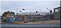
RAF plane
unusual sight to see an RAF plane at a scrapyard
Image: © Linda Craven
Taken: 30 Jul 2006
0.25 miles