IMAGES TAKEN NEAR TO
Hasprey Road, SANDBACH, CW11 3DY
Introduction
This page details the photographs taken nearby to Hasprey Road, CW11 3DY by members of the Geograph project.
The Geograph project started in 2005 with the aim of publishing, organising and preserving representative images for every square kilometre of Great Britain, Ireland and the Isle of Man.

There are currently over 7.5m images from over14,400 individuals and you can help contribute to the project by visiting https://www.geograph.org.uk
Image Map
Images are licensed for reuse under creativecommons.org/licenses/by-sa/2.0
Notes
- Clicking on the map will re-center to the selected point.
- The higher the marker number, the further away the image location is from the centre of the postcode.
Image Listing (45 Images Found)
Images are licensed for reuse under creativecommons.org/licenses/by-sa/2.0
Image
Details
Distance
1

Yew Tree Farm Booth Lane Sandbach from the Trent and Mersey Canal
Image: © Jo and Steve Turner
Taken: 17 Jun 1997
0.03 miles
4
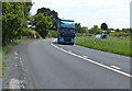
Lorry heading along the A533 Booth Lane
On the right is a narrowboat heading along the Trent & Mersey Canal.
Image: © Mat Fascione
Taken: 15 Jul 2015
0.07 miles

6
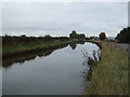
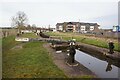
Trent & Mersey Canal near Stud Green
Looking north west.
Image: © JThomas
Taken: 29 Oct 2016
0.08 miles
7
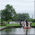
Narrowboat entering Lock No 68 near Middlewich, Cheshire
Image: © Roger D Kidd
Taken: 31 Aug 2011
0.08 miles
9
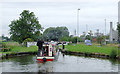
Narrowboat entering Lock No 68 near Middlewich, Cheshire
On the right is the former Albion (previously Cerebos) chemical works. The site has received permission for redevelopment.
"The 19 hectare site, which sits midway between Sandbach and Middlewich, was proposed for a wide range of uses including up to 375 dwellings, 12,000 sq.m of office development, 3,810 sq.m of general industrial, storage and distribution uses, a pub/hotel, a health club, local centre (retail) uses, and conversion of a listed farmhouse and farmyard for residential purposes."
http://www.walsinghamplanning.co.uk/our-work/mixed-use-development/albion-chemical-works.html
Image: © Roger D Kidd
Taken: 31 Aug 2011
0.08 miles
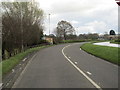
10
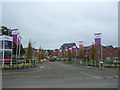
Littlemoor Road
New housing development off Booth Lane (A533).
Image: © JThomas
Taken: 29 Oct 2016
0.08 miles