IMAGES TAKEN NEAR TO
Bishops Close, SANDBACH, CW11 3AG
Introduction
This page details the photographs taken nearby to Bishops Close, CW11 3AG by members of the Geograph project.
The Geograph project started in 2005 with the aim of publishing, organising and preserving representative images for every square kilometre of Great Britain, Ireland and the Isle of Man.

There are currently over 7.5m images from over14,400 individuals and you can help contribute to the project by visiting https://www.geograph.org.uk
Image Map
Images are licensed for reuse under creativecommons.org/licenses/by-sa/2.0
Notes
- Clicking on the map will re-center to the selected point.
- The higher the marker number, the further away the image location is from the centre of the postcode.
Image Listing (51 Images Found)
Images are licensed for reuse under creativecommons.org/licenses/by-sa/2.0
Image
Details
Distance
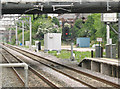
1
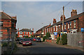
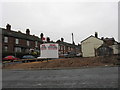
Hill Street, Elworth
This is part of the older part of Elworth which grew up in the vicinity of Sandbach railway station on the Crewe to Manchester line.
Image: © Alan Murray-Rust
Taken: 15 May 2008
0.12 miles
2
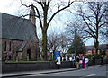
A Wedding at St Peter's Church, Elworth
Elworth lies about a mile to the west of Sandbach and straddles the A533 main road to Middlewich. The church is also on the A533.
Image: © michael ely
Taken: 24 Mar 2007
0.14 miles
3
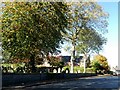
London Road, Elworth
A suburb of Sandbach. The graveyard is that of St. Peter's Church.
Image: © philandju
Taken: 18 Oct 2018
0.14 miles
4
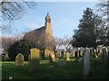
West end of St Peter's church, Elworth
An Anglican church, built in 1846 to the designs of Sir Gilbert Scott. Unlike most of his churches, this one is not listed. See also Image
Image: © Stephen Craven
Taken: 17 Apr 2016
0.16 miles
5
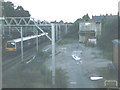
Site of former signalbox, Sandbach
The box shown in Image has since been demolished, and replaced by just a couple of small cabinets of electronic equipment. The area is now signalled from Stockport.
Image: © Stephen Craven
Taken: 16 May 2008
0.16 miles
6
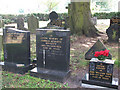
Grave of Gordon Bennett
The grave is in the churchyard of St Peter's Image The name caught my eye as it is a common expression - see http://www.phrases.org.uk/meanings/gordon-bennett.html for an explanation.
Image: © Stephen Craven
Taken: 27 Jun 2010
0.16 miles
7
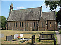
St Peter's church, Elworth - south side
An Anglican church, built in 1846 to the designs of Sir Gilbert Scott. This is the south side, viewed from the graveyard.
For the front (north) side of the church, see Image
Image: © Stephen Craven
Taken: 27 Jun 2010
0.16 miles
8
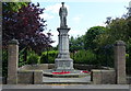
War memorial in Elworth, Sandbach
At the corner of the A533 London Road and Marsh Green Road.
Image: © Mat Fascione
Taken: 15 Jul 2015
0.16 miles
9
Sandbach signalbox (now demolished)
The signalbox dated from the 1960's electrification of the Manchester-Crewe line. The photo was taken in 2004, before the completion of the Manchester South resignalling project replaced it. It had been demolished by 2008 (see separate photo Image).
Image: © Stephen Craven
Taken: 2 Oct 2004
0.17 miles
10
View From The Entrance To Sandbach Station
Image: © Peter Whatley
Taken: 19 Jan 2010
0.17 miles