IMAGES TAKEN NEAR TO
Moss End, SANDBACH, CW11 2XH
Introduction
This page details the photographs taken nearby to Moss End, CW11 2XH by members of the Geograph project.
The Geograph project started in 2005 with the aim of publishing, organising and preserving representative images for every square kilometre of Great Britain, Ireland and the Isle of Man.

There are currently over 7.5m images from over14,400 individuals and you can help contribute to the project by visiting https://www.geograph.org.uk
Image Map
Images are licensed for reuse under creativecommons.org/licenses/by-sa/2.0
Notes
- Clicking on the map will re-center to the selected point.
- The higher the marker number, the further away the image location is from the centre of the postcode.
Image Listing (7 Images Found)
Images are licensed for reuse under creativecommons.org/licenses/by-sa/2.0
Image
Details
Distance
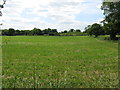
3
Trees around a pond, near Moss End
On the west side of Moorhead Lane.
Image: © Christine Johnstone
Taken: 15 Dec 2013
0.12 miles
4
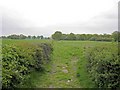
path at Brookhouse Moss
From Moss End Lane, this path continues along the left edge of the wood ahead, coming out near Brookhouse Green.
Image: © John Robinson
Taken: 4 May 2007
0.14 miles
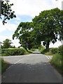
5
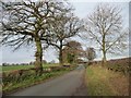
Moorhead Lane
Heading north-west, towards Spark Lane.
Image: © Christine Johnstone
Taken: 15 Dec 2013
0.15 miles
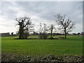
6
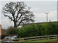
Winter tree, Moss End Farm Barns
Towering above the buildings and the leylandii.
Image: © Christine Johnstone
Taken: 15 Dec 2013
0.24 miles
7
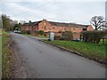
Moss End Farm Barns, Moss End Lane
Once agricultural, now converted to homes.
Image: © Christine Johnstone
Taken: 15 Dec 2013
0.25 miles