IMAGES TAKEN NEAR TO
Martins Moss Lane, SANDBACH, CW11 2UW
Introduction
This page details the photographs taken nearby to Martins Moss Lane, CW11 2UW by members of the Geograph project.
The Geograph project started in 2005 with the aim of publishing, organising and preserving representative images for every square kilometre of Great Britain, Ireland and the Isle of Man.

There are currently over 7.5m images from over14,400 individuals and you can help contribute to the project by visiting https://www.geograph.org.uk
Image Map
Images are licensed for reuse under creativecommons.org/licenses/by-sa/2.0
Notes
- Clicking on the map will re-center to the selected point.
- The higher the marker number, the further away the image location is from the centre of the postcode.
Image Listing (7 Images Found)
Images are licensed for reuse under creativecommons.org/licenses/by-sa/2.0
Image
Details
Distance
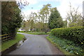
1
Martin's Moss
The waymark fingerpost by the gate leads to Brookhouse Green.
Image: © Peter Turner
Taken: 21 Apr 2012
0.02 miles
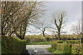
4
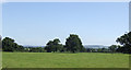
Cheshire grassland
This view south-east from Martin's Moss takes in a distant view of Mow Cop Hill in Staffordshire.
Image: © Jonathan Billinger
Taken: 22 Aug 2007
0.15 miles
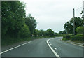
5
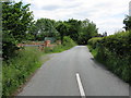
Mill Lane - the western extremity
The lane markings indicate the approach to the A50 junction.
Image: © Peter Whatley
Taken: 15 Jun 2010
0.16 miles