IMAGES TAKEN NEAR TO
Newcastle Road, SANDBACH, CW11 2UG
Introduction
This page details the photographs taken nearby to Newcastle Road, CW11 2UG by members of the Geograph project.
The Geograph project started in 2005 with the aim of publishing, organising and preserving representative images for every square kilometre of Great Britain, Ireland and the Isle of Man.

There are currently over 7.5m images from over14,400 individuals and you can help contribute to the project by visiting https://www.geograph.org.uk
Image Map
Images are licensed for reuse under creativecommons.org/licenses/by-sa/2.0
Notes
- Clicking on the map will re-center to the selected point.
- The higher the marker number, the further away the image location is from the centre of the postcode.
Image Listing (18 Images Found)
Images are licensed for reuse under creativecommons.org/licenses/by-sa/2.0
Image
Details
Distance
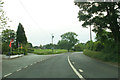
2
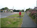
Newcastle Road (A50), Arclid
Showing position of Postbox No. CW11 67.
See Image] for postbox.
Image: © JThomas
Taken: 11 Jun 2016
0.07 miles
3
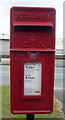
Close up, Elizabeth II postbox on Newcastle Road
Postbox No. CW11 67.
See Image] for wider view.
Image: © JThomas
Taken: 11 Jun 2016
0.07 miles
4
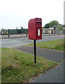
Elizabeth II postbox on Newcastle Road
Image: © JThomas
Taken: 11 Jun 2016
0.07 miles
6
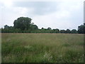
Grassland near Arclid
Off Newcastle Road (A50).
Image: © JThomas
Taken: 11 Jun 2016
0.08 miles
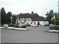
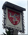
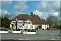
10
A50, Newcastle Road
Passing the Legs of Man public house.
Image: © Peter Bond
Taken: 17 Jun 2013
0.12 miles