IMAGES TAKEN NEAR TO
Mill Lane, SANDBACH, CW11 2GD
Introduction
This page details the photographs taken nearby to Mill Lane, CW11 2GD by members of the Geograph project.
The Geograph project started in 2005 with the aim of publishing, organising and preserving representative images for every square kilometre of Great Britain, Ireland and the Isle of Man.

There are currently over 7.5m images from over14,400 individuals and you can help contribute to the project by visiting https://www.geograph.org.uk
Image Map
Images are licensed for reuse under creativecommons.org/licenses/by-sa/2.0
Notes
- Clicking on the map will re-center to the selected point.
- The higher the marker number, the further away the image location is from the centre of the postcode.
Image Listing (11 Images Found)
Images are licensed for reuse under creativecommons.org/licenses/by-sa/2.0
Image
Details
Distance
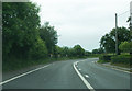
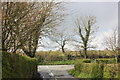
2
Mill Lane - the western extremity
The lane markings indicate the approach to the A50 junction.
Image: © Peter Whatley
Taken: 15 Jun 2010
0.05 miles
3
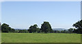
Cheshire grassland
This view south-east from Martin's Moss takes in a distant view of Mow Cop Hill in Staffordshire.
Image: © Jonathan Billinger
Taken: 22 Aug 2007
0.07 miles
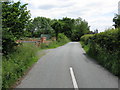
6
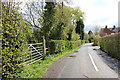
Martin's Moss
The waymark fingerpost by the gate leads to Brookhouse Green.
Image: © Peter Turner
Taken: 21 Apr 2012
0.19 miles
7
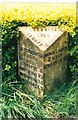
Old Milepost by the A50, north of Fourlanes End
Cast iron post by the A50, in parish of Smallwood (Congleton District), School Farm, between pavement and hedge, on West side of road. Cast iron CCC1898, erected by the County Council in the 19th century.
Inscription reads:-
: BRERETON GREEN / 3 MILES / HOLMES / CHAPEL 5 / KNUTSFORD 13 / WARRINGTON 24 / LIVERPOOL 43 : : CHESHIRE / 1898 / COUNTY COUNCIL : : CHURCH LAWTON / 3 MILES / NEWCASTLE / 10 :
Maker:-
: W H SMITH & CO / MAKERS / WHITCHURCH :
Milestone Society National ID: CH_NCWA10
Image: © J Higgins
Taken: 1 May 2003
0.20 miles
8
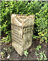
Old Milepost by the A50, north of Fourlanes End
Cast iron post by the A50, in parish of Smallwood (Congleton District), School Farm, between pavement and hedge, on West side of road. Cast iron CCC1898, erected by the County Council in the 19th century. An earlier photograph can be found here https://www.geograph.org.uk/photo/5622798.
Inscription reads:-
: BRERETON GREEN / 3 MILES / HOLMES / CHAPEL 5 / KNUTSFORD 13 / WARRINGTON 24 / LIVERPOOL 43 : : CHESHIRE / 1898 / COUNTY COUNCIL : : CHURCH LAWTON / 3 MILES / NEWCASTLE / 10 :
Maker:-
: W H SMITH & CO / MAKERS / WHITCHURCH :
Milestone Society National ID: CH_NCWA10
Image: © Nigel Upton
Taken: 3 Aug 2023
0.20 miles
9
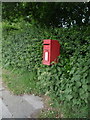
Elizabeth II postbox on Newcastle Road
Image: © JThomas
Taken: 11 Jun 2016
0.21 miles
10
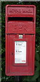
Close up, Elizabeth II postbox on Newcastle Road
Postbox No. CW11 81.
See Image] for wider view.
Image: © JThomas
Taken: 11 Jun 2016
0.21 miles