IMAGES TAKEN NEAR TO
School Lane, SANDBACH, CW11 1RT
Introduction
This page details the photographs taken nearby to School Lane, CW11 1RT by members of the Geograph project.
The Geograph project started in 2005 with the aim of publishing, organising and preserving representative images for every square kilometre of Great Britain, Ireland and the Isle of Man.

There are currently over 7.5m images from over14,400 individuals and you can help contribute to the project by visiting https://www.geograph.org.uk
Image Map
Images are licensed for reuse under creativecommons.org/licenses/by-sa/2.0
Notes
- Clicking on the map will re-center to the selected point.
- The higher the marker number, the further away the image location is from the centre of the postcode.
Image Listing (15 Images Found)
Images are licensed for reuse under creativecommons.org/licenses/by-sa/2.0
Image
Details
Distance
1
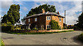
Broadhey Lodge
Broadhey Lodge at the corner of School Lane and Bagmere Lane.
Image: © Peter McDermott
Taken: 28 Aug 2017
0.01 miles
4
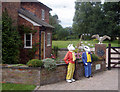
Rupert plays Quidditch
outside Broad Hey Lodge with Hedwig perched on the gatepost. Look closely and you can see the snitch hovering between the trees. Magic!
Image: © Neil Lewin
Taken: 3 Aug 2007
0.04 miles
5
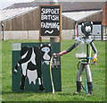
Robotic Milker
One entry in the Brereton Bear Festival 2007. There are 163 in the village raising money for St Oswald's Church
Image: © Neil Lewin
Taken: 3 Aug 2007
0.06 miles
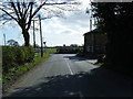
6
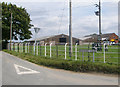
Bagshaw Lane
On the right is part of Lightfoot Green Farm.
Image: © Peter Whatley
Taken: 15 Jun 2010
0.07 miles
7
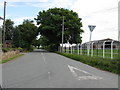
![Moorhead Lane [1]](https://s3.geograph.org.uk/geophotos/03/78/27/3782739_b5a658ad_120x120.jpg)
Moorhead Lane [1]
Heading north-west towards Brereton Green.
Image: © Christine Johnstone
Taken: 15 Dec 2013
0.07 miles
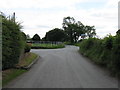
9
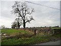
Trees on a field boundary, near Lightfoot Green Farm
On the west side of Moorhead Lane.
Image: © Christine Johnstone
Taken: 15 Dec 2013
0.08 miles
10
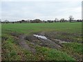
Muddy field entrance off Moorhead Lane
South-east of Lightfoot Green Farm.
Image: © Christine Johnstone
Taken: 15 Dec 2013
0.09 miles