IMAGES TAKEN NEAR TO
Middlewich Road, SANDBACH, CW11 1DH
Introduction
This page details the photographs taken nearby to Middlewich Road, CW11 1DH by members of the Geograph project.
The Geograph project started in 2005 with the aim of publishing, organising and preserving representative images for every square kilometre of Great Britain, Ireland and the Isle of Man.

There are currently over 7.5m images from over14,400 individuals and you can help contribute to the project by visiting https://www.geograph.org.uk
Image Map
Images are licensed for reuse under creativecommons.org/licenses/by-sa/2.0
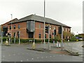
Notes
- Clicking on the map will re-center to the selected point.
- The higher the marker number, the further away the image location is from the centre of the postcode.
Image Listing (296 Images Found)
Images are licensed for reuse under creativecommons.org/licenses/by-sa/2.0
Image
Details
Distance
1
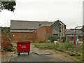
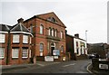
The Wesley Centre, Sandbach
The former Methodist Sunday School on Chapel Street Image was redeveloped and extended in 2006 to form a modern church and community hall.
Image: © Stephen Craven
Taken: 17 Oct 2021
0.02 miles
2
Junction of Middlewich Road and Old Middlewich Road
Old Middlewich Road is in the foreground, now cut off (other than for cycles) where its successor joins it. The pedestrian crossing leads to a retail park (Aldi and McDonalds).
Image: © Stephen Craven
Taken: 17 Oct 2021
0.02 miles
3
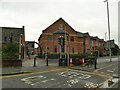
Former Methodist Sunday School, Sandbach
This side of the building on Chapel Street bears the legend 'Wesleyan Sunday Schools' and the date 1871; it is grade II listed along with the church to which it belonged Image In 2006 it was refurbished and extended to form the Wesley Centre, now approached from the other side Image
Image: © Stephen Craven
Taken: 17 Oct 2021
0.03 miles
4
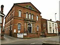
Sandbach Unity Methodist church, Wesley Avenue
Dating from 1870, originally a Wesleyan chapel, and grade II listed (list entry 1239994). See also Image
Image: © Stephen Craven
Taken: 17 Oct 2021
0.03 miles
5
Sandbach Methodist Church
On, appropriately, Wesley Avenue; built c1870, listed by Historic England: http://www.imagesofengland.org.uk/Details/Default.aspx?id=351192&mode=adv
Image: © Mike Faherty
Taken: 24 Jan 2017
0.03 miles
6
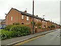
Houses on Chapel Street, Sandbach
This looks like a thorough refurbishment of older terraced housing, rather than new build, judging by the chimney pots.
Image: © Stephen Craven
Taken: 17 Oct 2021
0.03 miles
7
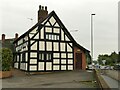
Poole Alcock LLP, Middlewich Road, Sandbach
The timber framed building is listed grade II (list entry 1130368) where it is described as 'Late C17 but much altered.' It now houses a firm of solicitors.
Image: © Stephen Craven
Taken: 17 Oct 2021
0.04 miles
8
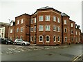
Modern building, Bradwall Street, Sandbach
On the corner of Wesley Street.
Image: © Stephen Craven
Taken: 17 Oct 2021
0.05 miles
9
Ashfields Medical Centre, Middlewich Road, Sandbach
The centre was opened around the same time as the adjacent Aldi supermarket; the practice was formerly based on Scotch Common and that building is now charity offices Image
Image: © Stephen Craven
Taken: 17 Oct 2021
0.05 miles
10
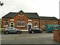
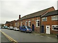
Former Providence School, Chapel Street, Sandbach
A former primary school, dating from 1869. Unlike the nearby Sunday School of similar date Image it is not listed, and is currently used by the Scouts.
Image: © Stephen Craven
Taken: 17 Oct 2021
0.05 miles