IMAGES TAKEN NEAR TO
The Gardens, SANDBACH, CW11 1BB
Introduction
This page details the photographs taken nearby to The Gardens, CW11 1BB by members of the Geograph project.
The Geograph project started in 2005 with the aim of publishing, organising and preserving representative images for every square kilometre of Great Britain, Ireland and the Isle of Man.

There are currently over 7.5m images from over14,400 individuals and you can help contribute to the project by visiting https://www.geograph.org.uk
Image Map
Images are licensed for reuse under creativecommons.org/licenses/by-sa/2.0
Notes
- Clicking on the map will re-center to the selected point.
- The higher the marker number, the further away the image location is from the centre of the postcode.
Image Listing (387 Images Found)
Images are licensed for reuse under creativecommons.org/licenses/by-sa/2.0
Image
Details
Distance
1
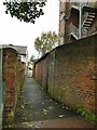
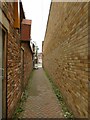
Path from Flat Lane to Hope Street
The path links the dead end of Hope Street to the high street via Flat Lane Image
Image: © Stephen Craven
Taken: 17 Oct 2021
0.02 miles
2
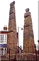
The Sandbach crosses ? side view, Market Place, Sandbach
These were broken up in the 17C, but were restored in 1816. They are considered to be from the 9C, and show biblical scenes (from Pevsner).
Image: © Humphrey Bolton
Taken: 13 Apr 2001
0.04 miles
3
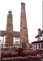
The Sandbach crosses ? rear and side view, Market Place, Sandbach
The back of the nearer cross has an elegant scroll design. There is a dragon on the north face of the north cross (from Pevsner).
Image: © Humphrey Bolton
Taken: 13 Apr 2001
0.04 miles
4
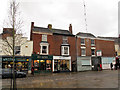
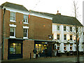
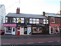
Shops and closed bank
This photo shows Brooks butchers, two independent clothes shops and what was until September 2012 the HSBC (formerly Midland) bank.
Image: © Stephen Craven
Taken: 31 Dec 2012
0.04 miles
5
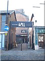
William Hill comes to Sandbach
Yet another high street betting shop, this time taking over the former Midland/HSBC bank building Image
Image: © Stephen Craven
Taken: 29 Dec 2013
0.04 miles
6
The north end of Flat Lane
The lane predates all the 19th-21st century developments south of the high street, and runs for 1km to Mill Hill. This is the other end approaching the High Street where it now takes the form of a narrow passageway between shops. It is marked on OS maps as a public footpath.
Image: © Stephen Craven
Taken: 17 Oct 2021
0.04 miles
7
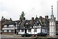
Sandbach
"Olde Worlde" buildings near the memorial in Sandbach
Image: © www fotodiscs4u co uk
Taken: 12 Nov 2006
0.04 miles
8
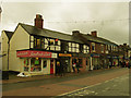
Shops on the west side of the High Street
This photo shows a card shop, (closed) pawnbrokers, cafe, and Boots the Chemist which is one of the few national chains on the high street.
Within two years after this photo was taken, three of the four shops nearest the camera had changed hands - see Image
Image: © Stephen Craven
Taken: 31 Dec 2012
0.04 miles
9
Cheshire E-cigs, Sandbach
"Cheshire e-cigs" is one of two e-cigarette shops to open on Sandbach High Street in 2014, reflecting a new trend. See also Image
Previously this had been a pawnbrokers; "The Hot Spot" (food takeaway) next door has also changed hands in the last two years, as has the cafe beyond that. See Image
Image: © Stephen Craven
Taken: 28 Dec 2014
0.04 miles
10
The Mill, Sandbach
The old factory building off Sandbach High Street has had several uses over the years but currently hosts a restaurant as well as an antiques centre.
Image: © Stephen Craven
Taken: 28 Dec 2014
0.04 miles