IMAGES TAKEN NEAR TO
Jack Lane, MIDDLEWICH, CW10 9JQ
Introduction
This page details the photographs taken nearby to Jack Lane, CW10 9JQ by members of the Geograph project.
The Geograph project started in 2005 with the aim of publishing, organising and preserving representative images for every square kilometre of Great Britain, Ireland and the Isle of Man.

There are currently over 7.5m images from over14,400 individuals and you can help contribute to the project by visiting https://www.geograph.org.uk
Image Map
Images are licensed for reuse under creativecommons.org/licenses/by-sa/2.0
Notes
- Clicking on the map will re-center to the selected point.
- The higher the marker number, the further away the image location is from the centre of the postcode.
Image Listing (1 Images Found)
Images are licensed for reuse under creativecommons.org/licenses/by-sa/2.0
Image
Details
Distance
1
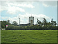
Winsford Salt Mine #4 Shaft
Winsford Salt Mine #4 Shaft #4. Seen from the footpath from Jack Lane, along the Bostock / Moulton boundary. The location of this shaft gives some idea of the extent of the underground workings of the Winsford salt mine. The main shaft and mine workings are over 1 km away to the SW. In fact the underground mine workings are far more extensive even than this.
Image: © Mike Harris
Taken: 19 May 2007
0.16 miles