IMAGES TAKEN NEAR TO
Northwich Road, MIDDLEWICH, CW10 9JE
Introduction
This page details the photographs taken nearby to Northwich Road, CW10 9JE by members of the Geograph project.
The Geograph project started in 2005 with the aim of publishing, organising and preserving representative images for every square kilometre of Great Britain, Ireland and the Isle of Man.

There are currently over 7.5m images from over14,400 individuals and you can help contribute to the project by visiting https://www.geograph.org.uk
Image Map
Images are licensed for reuse under creativecommons.org/licenses/by-sa/2.0
Notes
- Clicking on the map will re-center to the selected point.
- The higher the marker number, the further away the image location is from the centre of the postcode.
Image Listing (6 Images Found)
Images are licensed for reuse under creativecommons.org/licenses/by-sa/2.0
Image
Details
Distance
1
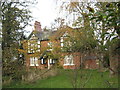
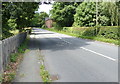
Greenhays Farmhouse in Bostock Road
Image: © Dr Duncan Pepper
Taken: 12 Nov 2011
0.09 miles
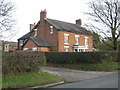
2
Greenheyes Farm
Typical agricultural view of the area.
Image: © Carys Brewster
Taken: 16 Nov 2006
0.12 miles
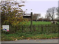
6
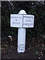
Old Milepost by the A533, Bostock Road, Stanthorne
Cast iron post by the A533, in parish of Stanthorne (Vale Royal District), Bostock Road; Greenhay's Farm, in hedge, on West side of road. Old domed open book 1833 casting, erected by the Spann Smithy, Booth Lane & Winsford turnpike trust in the 19th century.
Inscription reads:-
: NORTHWICH / 5 / MILES : : MIDDLEWICH / 1 / MILE / SANDBACH / 6 :
Parish, date and Maker's plate:-
: STANTHORNE / 1833 / W.E / M :
Grade II listed.
List Entry Number: 1139212 https://historicengland.org.uk/listing/the-list/list-entry/1139212
Milestone Society National ID: CH_NTMW05
Image: © John V Nicholls
Taken: 21 Mar 2009
0.21 miles