IMAGES TAKEN NEAR TO
Farley Close, MIDDLEWICH, CW10 0PU
Introduction
This page details the photographs taken nearby to Farley Close, CW10 0PU by members of the Geograph project.
The Geograph project started in 2005 with the aim of publishing, organising and preserving representative images for every square kilometre of Great Britain, Ireland and the Isle of Man.

There are currently over 7.5m images from over14,400 individuals and you can help contribute to the project by visiting https://www.geograph.org.uk
Image Map
Images are licensed for reuse under creativecommons.org/licenses/by-sa/2.0
Notes
- Clicking on the map will re-center to the selected point.
- The higher the marker number, the further away the image location is from the centre of the postcode.
Image Listing (52 Images Found)
Images are licensed for reuse under creativecommons.org/licenses/by-sa/2.0
Image
Details
Distance
1
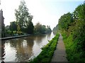
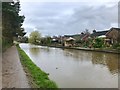
Shropshire Union Canal, Middlewich Branch
The ten mile long Middlewich Branch joins the Shropshire Union Canal to the Trent and Mersey Canal. This view is from the outskirts of Middlewich looking WNW. The next lock from here is Stanthorne.
Image: © David P Howard
Taken: 13 Oct 2010
0.03 miles
2
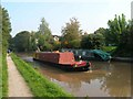
Shropshire Union Canal, Middlewich Branch
The ten mile long Middlewich Branch joins the Shropshire Union Canal to the Trent and Mersey Canal. This narrowboat is heading away from Middlewich towards Stanthorne Lock.
Image: © David P Howard
Taken: 13 Oct 2010
0.04 miles
3
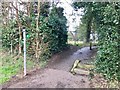
Hannah's Walk, Middlewich
Hannah's Walk is a public footpath designated Middlewich FP 8 and runs between St Ann's Road and the Shropshire Union Canal.
Image: © Jonathan Hutchins
Taken: 18 Mar 2017
0.05 miles
4
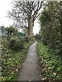
Hannah's Walk, Middlewich
Hannah's Walk is a public footpath designated Middlewich FP 8 and runs between St Ann's Road and the Shropshire Union Canal.
Image: © Jonathan Hutchins
Taken: 18 Mar 2017
0.05 miles
5
Shropshire Union Canal - Middlewich Branch
Image: © Jonathan Hutchins
Taken: 18 Mar 2017
0.06 miles
6
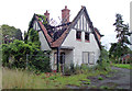
Derelict house in Middlewich, Cheshire
A fine detached property on a large plot of land by the canal has become derelict and ravaged by fire. It has now been demolished (October 2011). Outline permission to build six new detached houses was granted in 2009, but whether this is the current plan I know not.
Image: © Roger D Kidd
Taken: 27 Aug 2011
0.07 miles
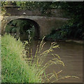
7

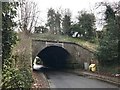
Bridge No 28 in Middlewich, Cheshire
The bridge was probably an accommodation bridge for farmers before housing was built on both sides of the canal. It is now used as a footpath and cycle route (Google maps is numbering it R71, but that confuses me).
The ten mile long Middlewich Branch of the former Chester Canal, with four locks, was opened in 1833, linking the main Chester Canal at Barbridge with the Trent and Mersey about four hundred metres ahead of this image. By 1845 an amalgam of canals and railways resulted in the formation of the Shropshire Union Railways and Canal Company.
Image: © Roger D Kidd
Taken: 27 Aug 2011
0.08 miles
8
Aqueduct over Nantwich Road, Middlewich
Grade II listed, see https://www.historicengland.org.uk/listing/the-list/list-entry/1229541
Image: © Jonathan Hutchins
Taken: 18 Mar 2017
0.09 miles
9
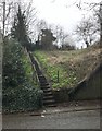
Steps up to Shropshire Union Canal, Middlewich
Image: © Jonathan Hutchins
Taken: 18 Mar 2017
0.09 miles
10
Canal bank in Middlewich, Cheshire
Bridge No 28 was probably an accommodation bridge for farmers and a manor before housing was built on both sides of the canal. It is now used as a footpath and cycle route (Google maps is numbering it R71, whatever that means - certainly not the national R71 route further north).
The ten mile long Middlewich Branch of the former Chester Canal, with four locks, was opened in 1833, linking the main Chester Canal at Barbridge with the Trent and Mersey about four hundred metres ahead of this image. By 1845 an amalgam of canals and railways resulted in the formation of the Shropshire Union Railways and Canal Company.
Image: © Roger D Kidd
Taken: 27 Aug 2011
0.09 miles