IMAGES TAKEN NEAR TO
Hollins Green, MIDDLEWICH, CW10 0LA
Introduction
This page details the photographs taken nearby to Hollins Green, CW10 0LA by members of the Geograph project.
The Geograph project started in 2005 with the aim of publishing, organising and preserving representative images for every square kilometre of Great Britain, Ireland and the Isle of Man.

There are currently over 7.5m images from over14,400 individuals and you can help contribute to the project by visiting https://www.geograph.org.uk
Image Map
Images are licensed for reuse under creativecommons.org/licenses/by-sa/2.0
Notes
- Clicking on the map will re-center to the selected point.
- The higher the marker number, the further away the image location is from the centre of the postcode.
Image Listing (11 Images Found)
Images are licensed for reuse under creativecommons.org/licenses/by-sa/2.0
Image
Details
Distance
1
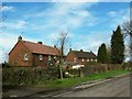
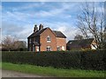
Houses at Hollins Green
These look like mid-20th century houses for agricultural workers.
Image: © Stephen Craven
Taken: 29 Mar 2016
0.02 miles
2
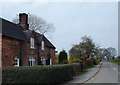
Hollinsgreen, Cheshire
Hollinsgreen is a collection of attractive cottages along Wood Lane. The hamlet is situated in the centre of a triangle formed by the towns of Holmes Chapel, Middlewich and Sandbach. View looking north up Wood Lane.
Image: © michael ely
Taken: 24 Mar 2007
0.03 miles
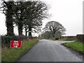
3
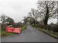
Hollins Green Is Closed
The caption refers to the unusually named lane, not the place.
Image: © Peter Whatley
Taken: 19 Jan 2010
0.04 miles
4
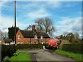
Wood Lane, Hollins Green
With a tractor and trailer rounding the bend.
Image: © Stephen Craven
Taken: 29 Mar 2016
0.06 miles
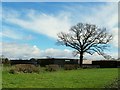
5
Cherry Tree Cottage, Hollins Green
Typical of the area.
Image: © Stephen Craven
Taken: 29 Mar 2016
0.06 miles
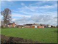
6
Silos at Wood Lane Farm, Hollins Green
Probably for holding slurry from dairy cattle.
Image: © Stephen Craven
Taken: 29 Mar 2016
0.13 miles
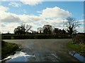
7
Bradwall Road At Hollins Green Junction
Image: © Peter Whatley
Taken: 19 Jan 2010
0.13 miles
8
Hollinswood Far, Hollins Green
According to the sign at the gate, an organic dairy farm.
Image: © Stephen Craven
Taken: 29 Mar 2016
0.14 miles
9
Road junction near Hollins Green
A staggered junction where Jones's Lane (foreground) and Wood Lane (beyond) meet Bradwall Road (centre).
Image: © Stephen Craven
Taken: 29 Mar 2016
0.14 miles
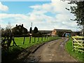
10
Wood Lane Farm, Hollins Green
A dairy farm.
Image: © Stephen Craven
Taken: 29 Mar 2016
0.20 miles