IMAGES TAKEN NEAR TO
Quarry Lane, ATHERSTONE, CV9 2RD
Introduction
This page details the photographs taken nearby to Quarry Lane, CV9 2RD by members of the Geograph project.
The Geograph project started in 2005 with the aim of publishing, organising and preserving representative images for every square kilometre of Great Britain, Ireland and the Isle of Man.

There are currently over 7.5m images from over14,400 individuals and you can help contribute to the project by visiting https://www.geograph.org.uk
Image Map
Images are licensed for reuse under creativecommons.org/licenses/by-sa/2.0
Notes
- Clicking on the map will re-center to the selected point.
- The higher the marker number, the further away the image location is from the centre of the postcode.
Image Listing (26 Images Found)
Images are licensed for reuse under creativecommons.org/licenses/by-sa/2.0
Image
Details
Distance
1
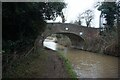
Worthington Farm Bridge south of Mancetter, Warwickshire
Looking north, Worthington Farm Bridge is No 35 across the Coventry Canal. Worthington Farm is now called Stoneleigh Quarry Farm, so I suppose the bridge will be having two names. The quarry (off to the left) was a post-Victorian enterprise, by 2020 flooded and developed as a canal boat marina. Aerial images show that this could be extended to the south-east. https://www.towpathtalk.co.uk/brand-new-picturesque-marina-opening-in-warwickshire/
Image: © Roger Kidd
Taken: 25 Sep 2016
0.15 miles
4

Worthington Farm Bridge south of Mancetter, Warwickshire
Looking north, Worthington Farm Bridge is No 35 across the Coventry Canal. Worthington Farm is now called Stoneleigh Quarry Farm, so I suppose the bridge will be having two names. The quarry (off to the left) was a post-Victorian enterprise, by 2020 flooded and developed as a canal boat marina. https://www.towpathtalk.co.uk/brand-new-picturesque-marina-opening-in-warwickshire/
Image: © Roger Kidd
Taken: 25 Sep 2016
0.15 miles
5
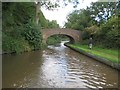
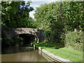
Coventry Canal: Bridge Number 35: Stoneleigh Quarry Bridge
The number plates on the bridges on the Coventry Canal are generally well-looked after. This one however appears to have escaped the attention of the maintenance team as it is entirely rusty and almost indistinguishable at a distance from the brickwork. The bridge takes Quarry Lane over the canal.
Image: © Nigel Cox
Taken: 11 Sep 2012
0.15 miles
6
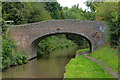
Stoneleigh Quarry Farm Bridge No 35
Crossing the Coventry Canal south of Mancetter.
Image: © Mat Fascione
Taken: 13 Sep 2015
0.15 miles
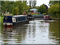
7
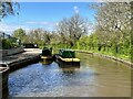
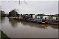
Workboats on the Coventry Canal
Near Mancetter.
Image: © Andrew Abbott
Taken: 1 May 2023
0.15 miles
8
Coventry Canal north of Bridge 35 near Mancetter
This 2016 image shows the canal, looking north towards Atherstone from near Worthington Farm Bridge. The land on the left has now been developed (2021) but as Streetview hasn't been anywhere near here, I am not sure yet whether that is connected to the new marina replacing the quarry south of the bridge.
Image: © Roger Kidd
Taken: 25 Sep 2016
0.15 miles
9
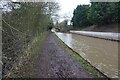
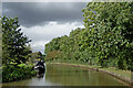
Narrowboats moored along the Coventry Canal
This stretch of the canal is between bridges 35 and 36.
Image: © Mat Fascione
Taken: 13 Sep 2015
0.16 miles