IMAGES TAKEN NEAR TO
Merevale Road, ATHERSTONE, CV9 2PR
Introduction
This page details the photographs taken nearby to Merevale Road, CV9 2PR by members of the Geograph project.
The Geograph project started in 2005 with the aim of publishing, organising and preserving representative images for every square kilometre of Great Britain, Ireland and the Isle of Man.

There are currently over 7.5m images from over14,400 individuals and you can help contribute to the project by visiting https://www.geograph.org.uk
Image Map
Images are licensed for reuse under creativecommons.org/licenses/by-sa/2.0
Notes
- Clicking on the map will re-center to the selected point.
- The higher the marker number, the further away the image location is from the centre of the postcode.
Image Listing (193 Images Found)
Images are licensed for reuse under creativecommons.org/licenses/by-sa/2.0
Image
Details
Distance
1
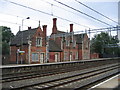
Atherstone Station
According to the Image the elegant station buildings were restored in 1985. Sadly since then they have slowly been allowed to deteriorate again.
Image: © David Stowell
Taken: 29 Jul 2006
0.01 miles
2
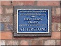
Plaque at Atherstone Station
Commemorating the restoration of Image buildings to something like their former glory. Sadly the sign, like the station buildings themselves seems to have been lacking tlc in more recent times and the good work is at risk of being reversed.
Image: © David Stowell
Taken: 29 Jul 2006
0.01 miles
3
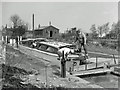
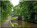
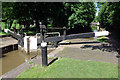
Atherstone lock 4, 1964
On the far right Atherstone station platforms may be seen. Between the canal and the railway in now residential development, but in 1944 a government instigated rail-served grain store was built here, one of several across the country. It may have still been there in 1964, just out of sight to the right. The boat is being cleaned as return to the hire base at Stretton Stop was only three locks away, plus the trivial ones at Hawkesbury Junction.
Image: © Robin Webster
Taken: 9 Apr 1964
0.02 miles
4
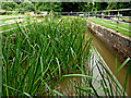
Lock sidepond north-west of Atherstone, Warwickshire
The side ponds are no longer in use on the Atherstone flight of locks. This one is by Lock No 4, looking north (downhill).
There is a video on You-Tube showing one of the Atherstone sideponds being used: https://www.youtube.com/watch?v=QiOgADpax2M
On the Coventry Canal, the Atherstone flight of eleven lowers (or raises) the water level by eighty feet (24.4 metres) over about two miles (three kilometres). As the canal company had run out of money by 1771 when it reached Atherstone on its course from Coventry, these locks and the rest of the route were constructed later, eventually arriving at Fazeley in 1790.
Image: © Roger D Kidd
Taken: 19 Aug 2013
0.02 miles
5
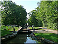
Lock No 4 at Atherstone in Warwickshire
This is the Coventry Canal, looking south-south-east towards Lock No 4 in the Atherstone flight of eleven.
Jo Turner adds:
Image: © Roger D Kidd
Taken: 19 Aug 2013
0.02 miles
6
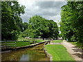
Lock No 4 at Atherstone in Warwickshire
Lock No 4, looking north-north-west (downhill).
On the Coventry Canal, the Atherstone flight of eleven locks lowers (or raises) the water level by eighty feet (24.4 metres) over about two miles (three kilometres). As the canal company had run out of money by 1771 when it reached Atherstone on its course from Coventry, these locks and the rest of the route were constructed later, eventually arriving at Fazeley in 1790.
Image: © Roger D Kidd
Taken: 19 Aug 2013
0.02 miles
7
Lock No 4 at Atherstone in Warwickshire
Lock No 4, looking north-north-west (downhill).
On the Coventry Canal, the Atherstone flight of eleven locks lowers (or raises) the water level by eighty feet (24.4 metres) over about two miles (three kilometres). As the canal company had run out of money by 1771 when it reached Atherstone on its course from Coventry, these locks and the rest of the route were constructed later, eventually arriving at Fazeley in 1790.
Jo Turner has written:
Image: © Roger D Kidd
Taken: 19 Aug 2013
0.02 miles
8
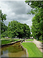
Atherstone Locks No 4 in Warwickshire
Lock No 4, looking north-north-west (downhill).
On the Coventry Canal, the Atherstone flight of eleven locks lowers (or raises) the water level by eighty feet (24.4 metres) over about two miles (three kilometres). As the canal company had run out of money by 1771 when it reached Atherstone on its course from Coventry, these locks and the rest of the route were constructed later, eventually arriving at Fazeley in 1790.
Jo Turner has written:
Image: © Roger D Kidd
Taken: 19 Aug 2013
0.02 miles
9
Atherstone Lock 4, Coventry Canal
Looking down from lock 4 towards lock 5 on a sunny afternoon. There are 11 locks in the Atherstone flight but they are grouped closer together at the top. The lock surrounds are kept very tidy here.
Image: © Stephen McKay
Taken: 9 Sep 2020
0.02 miles
10
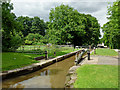
Atherstone Locks No 4 in Warwickshire
Looking north-west towards Polesworth and Fazeley Junction.
The flight of eleven Atherstone Locks on the Coventry Canal raises (or lowers) the water level by eighty feet (24·4 metres) over about two miles (three kilometres).
Image: © Roger Kidd
Taken: 15 Jun 2010
0.02 miles