IMAGES TAKEN NEAR TO
Main Road, ATHERSTONE, CV9 2LQ
Introduction
This page details the photographs taken nearby to Main Road, CV9 2LQ by members of the Geograph project.
The Geograph project started in 2005 with the aim of publishing, organising and preserving representative images for every square kilometre of Great Britain, Ireland and the Isle of Man.

There are currently over 7.5m images from over14,400 individuals and you can help contribute to the project by visiting https://www.geograph.org.uk
Image Map
Images are licensed for reuse under creativecommons.org/licenses/by-sa/2.0
Notes
- Clicking on the map will re-center to the selected point.
- The higher the marker number, the further away the image location is from the centre of the postcode.
Image Listing (4 Images Found)
Images are licensed for reuse under creativecommons.org/licenses/by-sa/2.0
Image
Details
Distance
1
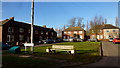
The Orchard, Baxterley
Housing in the centre of the now defunct Warwickshire coalfield.
Image: © Jonathan Billinger
Taken: 7 Feb 2017
0.06 miles
2
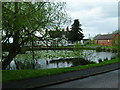
Baxterley Village Pub
This is located opposite the old Baddesley coal mine that has now gone past recognition. This is a lot more prettier.
Image: © Andy and Hilary
Taken: 7 May 2005
0.15 miles
3
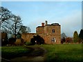
Unusual stone house, Baxterley
Whether this building is as old as it looks, or has been made from old materials I don't know. It is on the road to Hurley out of Baxterley.
The EH listing https://historicengland.org.uk/listing/the-list/list-entry/1034742 suggests that it is "probably" C18th but in a C16th style.
This lane also leads to the interesting Baxterley Church.
Image: © Rob Farrow
Taken: 22 Jan 2006
0.15 miles
4
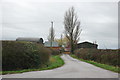
Driveway to Kiddle's Farm, Baxterley
The farm itself is in square SP2796.
Image: © Mick Malpass
Taken: 11 Dec 2011
0.20 miles