IMAGES TAKEN NEAR TO
Warren Close, COVENTRY, CV8 3JZ
Introduction
This page details the photographs taken nearby to Warren Close, CV8 3JZ by members of the Geograph project.
The Geograph project started in 2005 with the aim of publishing, organising and preserving representative images for every square kilometre of Great Britain, Ireland and the Isle of Man.

There are currently over 7.5m images from over14,400 individuals and you can help contribute to the project by visiting https://www.geograph.org.uk
Image Map (Loading...)


Getting Data...Please wait
Leaflet Map data © OpenStreetMap
Images are licensed for reuse under creativecommons.org/licenses/by-sa/2.0
Notes
- Clicking on the map will re-center to the selected point.
- The higher the marker number, the further away the image location is from the centre of the postcode.
Image Listing (15 Images Found)
Images are licensed for reuse under creativecommons.org/licenses/by-sa/2.0
Image
Details
Distance
1
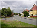
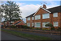
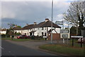
Ryton On Dunsmore High Street
High street is very much residential at this point.
Image: © Ian Rob
Taken: 7 Aug 2010
0.08 miles
2
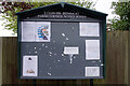
Ryton on Dunsmore Parish Council Notice Board
The notice board is located adjacent to the Co-op at the junction of High Street and Warren Field. The notices include information about a referendum on the local neighbourhood plan held on 6th May.
Image: © Stephen McKay
Taken: 28 May 2021
0.09 miles
3
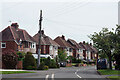
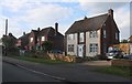
High Street, Ryton on Dunsmore
A line of semi-detached houses stretches away from the junction with Warren Field.
Image: © Stephen McKay
Taken: 28 May 2021
0.12 miles
4
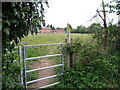
Footpath at Ryton
Cuts diagonally across the field, to cut the corner. The kissing gate is comparatively new, and replaces a somewhat rickety nettle-bound wood, metal and wire stile.
Image: © E Gammie
Taken: 29 Apr 2007
0.13 miles
5
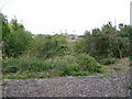
The back end of Ryton car plant
taken between the bars of the security fencing (see Image ). This end has been scrubland like this for some years. Beyond it can be seen the car parks where new models were stored before delivery, and in the distance, the chimneys of the plant itself in Image .
Production of Peugeots here came to an end on 12 Dec 2006 when the last car rolled off the line and with the loss of 2,300 jobs. Talk is of a distribution centre moving here with the creation of 400 jobs, lost from elsewhere. Cars produced here over the years: Humber, Hillman, Sunbeam, Singer 1945-68; Chrysler 1968-79; Talbot 1979-86; Peugeot 1986-2006.
Image: © E Gammie
Taken: 29 Apr 2007
0.13 miles
8
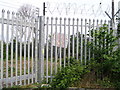
Defunct car plant - keep out
This is the back end of the Ryton car plant after closure by Peugeot. The sign has wording to the effect of " This land is the property of Peugeot Citroen UK Ltd. The general public has no right of access. To seek permission to enter the land and for general enquiries please contact security ...", the fence looks new, too. See Image for beyond the fence.
Image: © E Gammie
Taken: 29 Apr 2007
0.16 miles
10
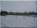
Coventry City FC training ground, Ryton
Looking bleak under the spring snowfall.
Compared with 2005 (Image), apart from the obvious weather difference, the main change is the addition of a fence.
Image: © E Gammie
Taken: 24 Mar 2013
0.20 miles