IMAGES TAKEN NEAR TO
Derry Close, COVENTRY, CV8 3JH
Introduction
This page details the photographs taken nearby to Derry Close, CV8 3JH by members of the Geograph project.
The Geograph project started in 2005 with the aim of publishing, organising and preserving representative images for every square kilometre of Great Britain, Ireland and the Isle of Man.

There are currently over 7.5m images from over14,400 individuals and you can help contribute to the project by visiting https://www.geograph.org.uk
Image Map
Images are licensed for reuse under creativecommons.org/licenses/by-sa/2.0
Notes
- Clicking on the map will re-center to the selected point.
- The higher the marker number, the further away the image location is from the centre of the postcode.
Image Listing (39 Images Found)
Images are licensed for reuse under creativecommons.org/licenses/by-sa/2.0
Image
Details
Distance
1
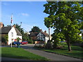
Wolston
Looking SE towards the village centre with the war memorial and some timbered cottages.
Image: © David Stowell
Taken: 15 Aug 2005
0.02 miles
2
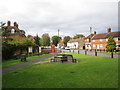
Wolston
The stream separates the Red Lion Public House and cottages from Main Street
Image: © Ian Rob
Taken: 5 May 2007
0.02 miles
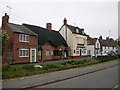
3
Main Street, Wolston
A brief burst of sunshine on an otherwise dull day brightens up the western side of Wolston's Main Street. There are hints of spring with crocuses growing on the stream bank. In common with many rural pubs at present, the Red Lion displays a 'To Let' sign.
Image: © Stephen McKay
Taken: 22 Feb 2009
0.04 miles
4
![The Brook [1]](https://s3.geograph.org.uk/geophotos/05/77/62/5776263_188cbd0a_120x120.jpg)
The Brook [1]
Known simply as The Brook, it flows along Main Street and into the River Avon a few hundred yards downstream.
Image: © Michael Dibb
Taken: 13 May 2018
0.04 miles
5
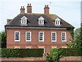
The Manor House
This fine Georgian style house is listed, grade II with details at: https://www.historicengland.org.uk/listing/the-list/list-entry/1185673
Image: © Michael Dibb
Taken: 13 May 2018
0.04 miles
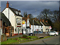
6
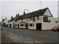
Wolston
Cottages and The Half Moon Public House, one of three pubs in the village.
Image: © Ian Rob
Taken: 5 May 2007
0.04 miles
8
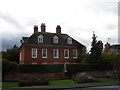
The Manor House, Wolston
Dates from the early eighteenth century https://historicengland.org.uk/listing/the-list/list-entry/1185673
Image: © Jonathan Thacker
Taken: 29 Sep 2019
0.04 miles
9
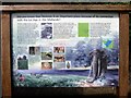
Information board
The board details the Ice Age in the Midlands and how the village lends its name to the Wolstonian sequence of deposits.
Image: © Michael Dibb
Taken: 13 May 2018
0.04 miles
10
![The Brook [2]](https://s0.geograph.org.uk/geophotos/05/77/62/5776264_5ff323e3_120x120.jpg)
The Brook [2]
Known simply as The Brook, it flows along Main Street and into the River Avon a few hundred yards downstream.
Image: © Michael Dibb
Taken: 13 May 2018
0.05 miles