IMAGES TAKEN NEAR TO
Dyers Lane, COVENTRY, CV8 3HE
Introduction
This page details the photographs taken nearby to Dyers Lane, CV8 3HE by members of the Geograph project.
The Geograph project started in 2005 with the aim of publishing, organising and preserving representative images for every square kilometre of Great Britain, Ireland and the Isle of Man.

There are currently over 7.5m images from over14,400 individuals and you can help contribute to the project by visiting https://www.geograph.org.uk
Image Map (Loading...)


Getting Data...Please wait
Leaflet Map data © OpenStreetMap
Images are licensed for reuse under creativecommons.org/licenses/by-sa/2.0
Notes
- Clicking on the map will re-center to the selected point.
- The higher the marker number, the further away the image location is from the centre of the postcode.
Image Listing (28 Images Found)
Images are licensed for reuse under creativecommons.org/licenses/by-sa/2.0
Image
Details
Distance
1
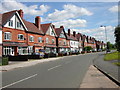
Wolston-School Street
Large houses on School Street.
Image: © Ian Rob
Taken: 20 May 2008
0.05 miles
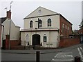
4
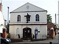
Baptist church
This plain church with a pedimented gable was erected in 1818 and probably replaced an earlier building.
Image: © Michael Dibb
Taken: 13 May 2018
0.08 miles
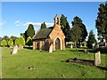
5
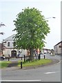
Jubilee Tree
The tree was planted to mark the Diamond Jubilee of Queen Victoria in 1897. The surrounding railings were erected to mark the Diamond Jubilee of Queen Elizabeth II in 2012.
Image: © Michael Dibb
Taken: 13 May 2018
0.09 miles
7
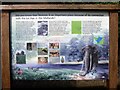
Information board
The board details the Ice Age in the Midlands and how the village lends its name to the Wolstonian sequence of deposits.
Image: © Michael Dibb
Taken: 13 May 2018
0.09 miles
8
![The Brook [1]](https://s3.geograph.org.uk/geophotos/05/77/62/5776263_188cbd0a_120x120.jpg)
The Brook [1]
Known simply as The Brook, it flows along Main Street and into the River Avon a few hundred yards downstream.
Image: © Michael Dibb
Taken: 13 May 2018
0.10 miles
10
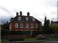
The Manor House, Wolston
Dates from the early eighteenth century https://historicengland.org.uk/listing/the-list/list-entry/1185673
Image: © Jonathan Thacker
Taken: 29 Sep 2019
0.11 miles