IMAGES TAKEN NEAR TO
Handley Close, COVENTRY, CV8 3FG
Introduction
This page details the photographs taken nearby to Handley Close, CV8 3FG by members of the Geograph project.
The Geograph project started in 2005 with the aim of publishing, organising and preserving representative images for every square kilometre of Great Britain, Ireland and the Isle of Man.

There are currently over 7.5m images from over14,400 individuals and you can help contribute to the project by visiting https://www.geograph.org.uk
Image Map
Images are licensed for reuse under creativecommons.org/licenses/by-sa/2.0
Notes
- Clicking on the map will re-center to the selected point.
- The higher the marker number, the further away the image location is from the centre of the postcode.
Image Listing (34 Images Found)
Images are licensed for reuse under creativecommons.org/licenses/by-sa/2.0
Image
Details
Distance
1
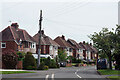
Ryton On Dunsmore Allotments
House and Allotments to the north of the A45.
Image: © Ian Rob
Taken: 5 Jan 2013
0.12 miles
2
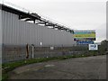
Ryton-Prologis Park
New Warehouses being constructed on the site of the former Peugeot works.
Image: © Ian Rob
Taken: 5 Jan 2013
0.15 miles
3
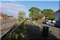
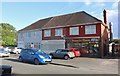
High Street, Ryton on Dunsmore
A line of semi-detached houses stretches away from the junction with Warren Field.
Image: © Stephen McKay
Taken: 28 May 2021
0.17 miles
5
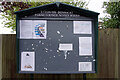
Ryton on Dunsmore Parish Council Notice Board
The notice board is located adjacent to the Co-op at the junction of High Street and Warren Field. The notices include information about a referendum on the local neighbourhood plan held on 6th May.
Image: © Stephen McKay
Taken: 28 May 2021
0.18 miles
6
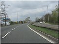
Lots of space available
A sign advertises empty lots available on the former Rootes Group car plant (later Chrysler and Peugeot-Citroen) which closed in December 2006.
Image: © Peter Whatley
Taken: 3 Apr 2012
0.19 miles
8
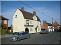
Ryton On Dunsmore-Church Road
The Malt Shovel Public House. Church Road is reached by a subway under the busy A45, from the main part of the Village.
Image: © Ian Rob
Taken: 5 Mar 2008
0.19 miles
9
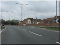
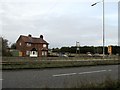
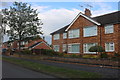
Houses by the A45, Ryton-on-Dunsmore
The modern estate is accessed off Church Road.
Image: © Peter Whatley
Taken: 3 Apr 2012
0.20 miles