IMAGES TAKEN NEAR TO
Bullimore Grove, KENILWORTH, CV8 2QF
Introduction
This page details the photographs taken nearby to Bullimore Grove, CV8 2QF by members of the Geograph project.
The Geograph project started in 2005 with the aim of publishing, organising and preserving representative images for every square kilometre of Great Britain, Ireland and the Isle of Man.

There are currently over 7.5m images from over14,400 individuals and you can help contribute to the project by visiting https://www.geograph.org.uk
Image Map (Loading...)


Getting Data...Please wait
Leaflet Map data © OpenStreetMap
Images are licensed for reuse under creativecommons.org/licenses/by-sa/2.0
Notes
- Clicking on the map will re-center to the selected point.
- The higher the marker number, the further away the image location is from the centre of the postcode.
Image Listing (30 Images Found)
Images are licensed for reuse under creativecommons.org/licenses/by-sa/2.0
Image
Details
Distance
1
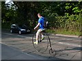
Penny Farthing on the Leamington Rd
This cyclist didn't care tuppence for safety as he was riding his penny farthing without a helmet on the busy A452 from Leamington just outside Kenilworth.
Image: © Nigel Mykura
Taken: 23 Apr 2011
0.05 miles
2
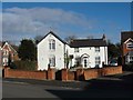
Hidden survivor
These buildings look to be among the few survivors of the former Victorian mansion called Cumnor in Kenilworth. The estate is now built over for housing and the main house is long gone, although the gatehouse has survived. Somehow, these buildings have also soldiered on and are split into two dwellings, although they look like they could do with some TLC. Kenilworth had several large Victorian mansions and mini-estates built by industrialists from Birmingham and elsewhere. Most are now gone and live on only in the names of some streets.
Image: © Colin Craig
Taken: 30 Jan 2009
0.10 miles
3
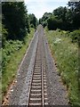
Railway line leaving Kenilworth heading for Leamington Spa
View south from the southern of the two bridges forming a road island on the A452 as it enters Kenilworth.
Image: © David P Howard
Taken: 22 Jun 2010
0.16 miles
4
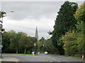
A452 Leamington Road Approaching Kenilworth
Image: © Roy Hughes
Taken: 9 Oct 2013
0.16 miles
5
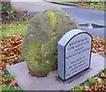
Old Boundary Marker by the former A429, Warwick Road, Kenilworth
Parish Boundary Marker by the UC (was A429), in parish of Kenilworth (Warwick District), Warwick Road, opposite the junction with Rouncil Lane on verge. Known as Betsy Smith's Grave.
Surveyed
Milestone Society National ID: WA_KENLEK01pb.
Image: © Milestone Society
Taken: Unknown
0.16 miles
6
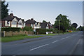
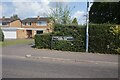
Warwick Road Kenilworth
A suburb of Kenilworth with wide grass verges is a very desirable part of Kenilworth.
Image: © Malcolm Neal
Taken: 26 May 2017
0.16 miles
7
Leamington Road, Kenilworth
A service road divides the houses from the main carriageway of the A452 on the outskirts of Kenilworth. A view in the opposite direction, featuring the postbox: Image
Image: © Stephen McKay
Taken: 8 May 2016
0.17 miles
8
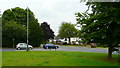
Junction of Rouncil Lane and Warwick Road
South of Kenilworth town centre.
Image: © Jonathan Billinger
Taken: 2 Jul 2008
0.18 miles
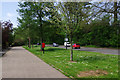
9
Vicarage Gardens off Rouncil Lane, Kenilworth
Image: © Ian S
Taken: 26 Jul 2021
0.18 miles
10

Warwick Road, Kenilworth
The old main road to Warwick before the new A46 changed the local configuration. It is bounded by fairly substantial residential properties.
Image: © Bill Boaden
Taken: 16 Jul 2022
0.18 miles