IMAGES TAKEN NEAR TO
Crewe Lane, KENILWORTH, CV8 2LA
Introduction
This page details the photographs taken nearby to Crewe Lane, CV8 2LA by members of the Geograph project.
The Geograph project started in 2005 with the aim of publishing, organising and preserving representative images for every square kilometre of Great Britain, Ireland and the Isle of Man.

There are currently over 7.5m images from over14,400 individuals and you can help contribute to the project by visiting https://www.geograph.org.uk
Image Map
Images are licensed for reuse under creativecommons.org/licenses/by-sa/2.0
Notes
- Clicking on the map will re-center to the selected point.
- The higher the marker number, the further away the image location is from the centre of the postcode.
Image Listing (23 Images Found)
Images are licensed for reuse under creativecommons.org/licenses/by-sa/2.0
Image
Details
Distance
1
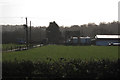
Redevelopment of Crewe Gardens farm under way
The tall evergreens in the distance are in the grounds of the former Woodside Hotel, also due to be redeveloped for housing.
Image: © Robin Stott
Taken: 27 May 2022
0.02 miles
2
Crewe Gardens Farm, Crew Lane near Kenilworth
"Supplier of top quality farm assured milk".
Image: © Robin Stott
Taken: 17 Jan 2010
0.07 miles
3
Sunday morning cyclist, Crew Lane near Kenilworth
Image: © Robin Stott
Taken: 17 Jan 2010
0.08 miles
4
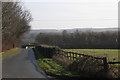
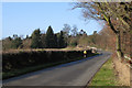
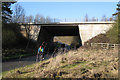
Crew Lane (2)
Going east from Kenilworth Crew Lane emerges from suburban treescape, turns southeast and descends, being bridged by the A46 at the bottom of the slope. On the skyline are Weston Wood and North Cubbington Wood: both are partly in Image
Image: © Robin Stott
Taken: 17 Jan 2010
0.08 miles
5
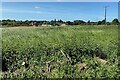
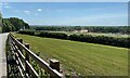
Crew Farm
Seen from Crew Lane with Glasshouse wood beyond.
Image: © David Stowell
Taken: 23 Jul 2005
0.08 miles
6
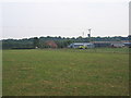
Signs of development off Crewe Lane
Housebuilders' flags and clouds of dust from earthmoving plant speak of residential development in the offing: a surprising sight. On the right edge of the photo are contractors' vehicles and behind them the derelict Crewe Gardens farm. It would appear from Warwick District Council and developers' websites that almost the entire triangle bounded by Glasshouse Lane, Crewe Lane and the A46 is to be developed for housing, an area in the order of 40 hectares.
Image: © Robin Stott
Taken: 27 May 2022
0.08 miles
7
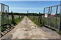
The road to Crewe Gardens farm, once
Beginning to be developed for housing.
Image: © Robin Stott
Taken: 27 May 2022
0.10 miles
9
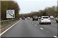
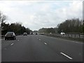
Sunday morning cyclist, Crew Lane
Where Crew Lane is crossed by the A46 dual carriageway.
Image: © Robin Stott
Taken: 17 Jan 2010
0.13 miles