IMAGES TAKEN NEAR TO
Crackley Lane, KENILWORTH, CV8 2JW
Introduction
This page details the photographs taken nearby to Crackley Lane, CV8 2JW by members of the Geograph project.
The Geograph project started in 2005 with the aim of publishing, organising and preserving representative images for every square kilometre of Great Britain, Ireland and the Isle of Man.

There are currently over 7.5m images from over14,400 individuals and you can help contribute to the project by visiting https://www.geograph.org.uk
Image Map (Loading...)


Getting Data...Please wait
Leaflet Map data © OpenStreetMap
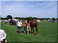
Images are licensed for reuse under creativecommons.org/licenses/by-sa/2.0
Notes
- Clicking on the map will re-center to the selected point.
- The higher the marker number, the further away the image location is from the centre of the postcode.
Image Listing (13 Images Found)
Images are licensed for reuse under creativecommons.org/licenses/by-sa/2.0
Image
Details
Distance
1
Approaching HS2 site access, Crackley Lane, near Westwood Heath
The site access, signed further along the road, is seen in Image
Image: © Robin Stott
Taken: 26 Mar 2021
0.12 miles
2

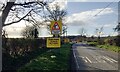
Showground, Crackley Lane
The sign explains it all. In the distance are buildings on the University of Warwick's Campus in Westwood, actually in the next square.
Image: © David Stowell
Taken: 27 Aug 2005
0.12 miles
3
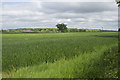
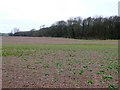
A field of winter wheat
A spring time crop that looks very healthy. I think it is winter wheat.
Image: © Malcolm Neal
Taken: 27 May 2017
0.13 miles
4
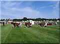
Cattle judging
The Kenilworth and District Agricultural Society (KADAS) show[1] at Hurst Farm Crackley Lane, early in the day. In the field shown in Image Also on show, alpacas, Tamworth pigs, and sheep.
Image: © E Gammie
Taken: 3 Jun 2007
0.14 miles
5
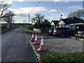
HS2 enabling works, Crackley-Burton Green, March 2021 (13)
At the sharp bend of Crackley Lane Image there is this contractor's compound with access to the preliminary works east of Burton Green.
Image: © Robin Stott
Taken: 26 Mar 2021
0.15 miles
6
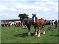
Suffolk Punch and foal
The heavy horse display in the main ring at the 2007 Kenilworth and District Agricultural Society (KADAS) show[1] at Hurst Farm Crackley Lane. In the field shown in Image
Image: © E Gammie
Taken: 3 Jun 2007
0.15 miles
7
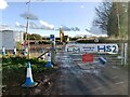
HS2 enabling works, Crackley-Burton Green, March 2021 (12)
To the left of the sharp bend of Crackley Lane there is a contractor's compound and access to the preliminary works east of Burton Green Image Photographed on 26 March, a Friday, yet the road is open despite the notification of closure from 23 March.
Image: © Robin Stott
Taken: 26 Mar 2021
0.15 miles
8
Broadwell Woods
A large deciduous woods just off Crackley lane.
Image: © Nigel Mykura
Taken: 6 Mar 2011
0.16 miles
9
Ploughing team
Waiting patiently to enter the main ring at the 2007 Kenilworth and District Agricultural Society (KADAS) show[1] at Hurst Farm Crackley Lane, in the field shown in Image Whitefield Coppice and a corner of the University of Warwick campus on the horizon, left.
Image: © E Gammie
Taken: 3 Jun 2007
0.17 miles
10
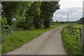
A country Lane outside Coventry
The back road from Coventry to Kenilworth passes this quiet country road.
Image: © Malcolm Neal
Taken: 27 May 2017
0.17 miles