IMAGES TAKEN NEAR TO
Convent Close, KENILWORTH, CV8 2FQ
Introduction
This page details the photographs taken nearby to Convent Close, CV8 2FQ by members of the Geograph project.
The Geograph project started in 2005 with the aim of publishing, organising and preserving representative images for every square kilometre of Great Britain, Ireland and the Isle of Man.

There are currently over 7.5m images from over14,400 individuals and you can help contribute to the project by visiting https://www.geograph.org.uk
Image Map
Images are licensed for reuse under creativecommons.org/licenses/by-sa/2.0
Notes
- Clicking on the map will re-center to the selected point.
- The higher the marker number, the further away the image location is from the centre of the postcode.
Image Listing (40 Images Found)
Images are licensed for reuse under creativecommons.org/licenses/by-sa/2.0
Image
Details
Distance
1
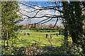
Croquet on a cold afternoon, Kenilworth
Spring has sprung and keen players are on the lawns at Kenilworth Tennis, Squash & Croquet Club.
Image: © Robin Stott
Taken: 31 Mar 2022
0.11 miles
3
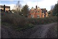
Semi-detached houses off Littleton Close, Kenilworth
These appealing houses are in the southwest corner of Kenilworth Common. They are shown on a map of 1887-88, connected by a path or drive to a large property called Crackley Hall long before Littleton Close was created. Perhaps the houses were occupied by servants.
Image: © Robin Stott
Taken: 22 Jan 2021
0.13 miles
4
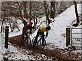
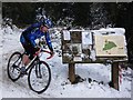
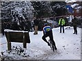
Kenilworth Cyclocross at the Quarry, 2010
The route of the Cyclocross across the Common includes this section in an area known as the Quarry, seen here from the main public footpath across the Common. This is the only time in the year that the gate seen here is ever opened and cyclists are allowed to use this area.
Image: © John Brightley
Taken: 26 Dec 2010
0.16 miles
5
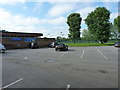
Carpark at the Tennis & Squash club
Kenilworth Tennis & Squash Club, on the northern side of the town.
Image: © Richard Law
Taken: 27 Jun 2019
0.17 miles
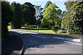
6
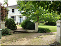
Kenilworth: The High House, Upper Ladyes Hills
I took this picture for sentimental reasons as in our second year at the then-new Warwick University (1967-8) a friend and I shared an attic flat in this rather grand house on a private road on the edge of Kenilworth.
Image: © John Sutton
Taken: 4 Jun 2019
0.17 miles
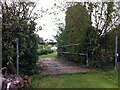
8
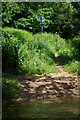
Ford through Finham Brook
The footpath goes over a bridge to the left.
Image: © Keith Williams
Taken: 8 Jun 2008
0.17 miles
9
Kenilworth Common Cyclocross 2010
A view from the main cross-common path towards the Forge Road entrance.
The rider is making a sharp left turn to go along the path that runs parallel and alongside Finham Brook.
Image: © John Brightley
Taken: 26 Dec 2010
0.17 miles
10
Bridge over the Finham Brook, Odibourne Allotments, Kenilworth
No doubt flooding is another hazard of allotment life here, but the stream must have enriched the fertility of the valley over the years. Not normally accessible to the public, the allotments were open as part of the Heritage Open Days 2021 and Edible England events.
Image: © A J Paxton
Taken: 18 Sep 2021
0.18 miles