IMAGES TAKEN NEAR TO
Coventry Road, KENILWORTH, CV8 2FG
Introduction
This page details the photographs taken nearby to Coventry Road, CV8 2FG by members of the Geograph project.
The Geograph project started in 2005 with the aim of publishing, organising and preserving representative images for every square kilometre of Great Britain, Ireland and the Isle of Man.

There are currently over 7.5m images from over14,400 individuals and you can help contribute to the project by visiting https://www.geograph.org.uk
Image Map (Loading...)


Getting Data...Please wait
Leaflet Map data © OpenStreetMap
Images are licensed for reuse under creativecommons.org/licenses/by-sa/2.0
Notes
- Clicking on the map will re-center to the selected point.
- The higher the marker number, the further away the image location is from the centre of the postcode.
Image Listing (47 Images Found)
Images are licensed for reuse under creativecommons.org/licenses/by-sa/2.0
Image
Details
Distance
1
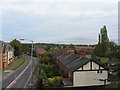
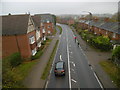
Kenilworth Road, Crackley
Looking north along the Kenilworth Road (A429) across a short section of farmland separating Kenilworth and Coventry. The terrace of houses to the right is Crackley Cottages and dates from around 1900. The houses to the left are comparatively recent (early 2000s) and replace the former Crackley Hill garage.
Image: © E Gammie
Taken: 9 Oct 2011
0.02 miles
2

Coventry Road in Crackley, Kenilworth
Viewed from the Kenilworth Greenway footbridge.
Image: © Mat Fascione
Taken: 18 Apr 2015
0.02 miles
3
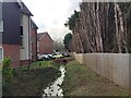
Drainage at rear of Laneham Place, Kenilworth
This is a watercourse that has been culverted to create space for car parking. Note the manner in which trees have been cut back to facilitate the construction of a fence on the property boundary. The imposing frontage of Laneham Place is seen in Image
Image: © Robin Stott
Taken: 22 Jan 2021
0.03 miles
4
Crackley Cottages
View from the Kenilworth Greenway Bridge which carried the old Kenilworth to Berkswell line.
Image: © Ian Rob
Taken: 19 May 2016
0.03 miles
5
Flats, Laneham Place, Kenilworth
A veritable periodic table of (building) elements in the Crackley area of Kenilworth. The rear of Laneham Place is less imposing: Image
Image: © Robin Stott
Taken: 22 Jan 2021
0.05 miles
6
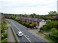
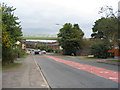
Crackley, A429
This section of the road from Kenilworth to Coventry; seen from Image
Image: © Mike Faherty
Taken: 17 Nov 2019
0.05 miles
7
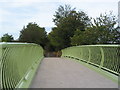
Crackley, footbridge
Crossing Coventry Road (A429), on the site of a former railway bridge, and on the Coventry Way. Joggers cause a disconcerting movement on the bridge when they use it.
Image: © Mike Faherty
Taken: 17 Nov 2019
0.05 miles
8
Greenway bridge, Crackley
As part of a Sustrans Connect2 project, a new foot/cycle bridge was installed over the A429 on the weekend of September 10/11 2011. Ultimately, the Kenilworth Greenway will connect Abbey Fields, Kenilworth with Berkswell and Burton Green, with an offshoot to the University of Warwick campus. Much of the route follows the former LNWR railway line between Kenilworth and Berkswell which was closed in 1969. The new bridge stands on the site of the rail overbridge which was demolished some years ago. At the time of the photo, the bridge was not yet open.
Update: The bridge was opened in the last week of September 2011.
http://www.geograph.org.uk/photo/2639293
Image: © E Gammie
Taken: 25 Sep 2011
0.05 miles
9
Greenway bridge, Crackley
The new foot and cycle bridge taking the Kenilworth Greenway over the A429 at Crackley opened at the end of September 2011.
See also http://www.geograph.org.uk/photo/2616716
Image: © E Gammie
Taken: 9 Oct 2011
0.05 miles
10
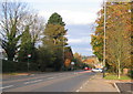
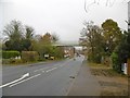
Crackley Hill, autumn
Looking towards Coventry down the main road between Kenilworth and Coventry (A429).
Image: © E Gammie
Taken: 2 Nov 2007
0.06 miles