IMAGES TAKEN NEAR TO
Seymour Green, CV8 1TX
Introduction
This page details the photographs taken nearby to Seymour Green, CV8 1TX by members of the Geograph project.
The Geograph project started in 2005 with the aim of publishing, organising and preserving representative images for every square kilometre of Great Britain, Ireland and the Isle of Man.

There are currently over 7.5m images from over14,400 individuals and you can help contribute to the project by visiting https://www.geograph.org.uk
Image Map
Images are licensed for reuse under creativecommons.org/licenses/by-sa/2.0
Notes
- Clicking on the map will re-center to the selected point.
- The higher the marker number, the further away the image location is from the centre of the postcode.
Image Listing (8 Images Found)
Images are licensed for reuse under creativecommons.org/licenses/by-sa/2.0
Image
Details
Distance
1
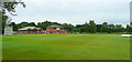
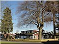
Kenilworth cricket ground
Pavilion and clubhouse viewed from the Warwick Road.
Image: © Jonathan Billinger
Taken: 2 Jul 2008
0.07 miles
2
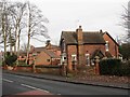
Cumnor Lodge, Kenilworth
This is one of the few surviving structures associated with the long-demolished Victorian mansion called Cumnor in Kenilworth. This Victorian lodge survives alongside a modern housing development built on the former grounds and site of the main house.
Image: © Colin Craig
Taken: 1 Feb 2009
0.13 miles
3
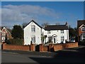
Hidden survivor
These buildings look to be among the few survivors of the former Victorian mansion called Cumnor in Kenilworth. The estate is now built over for housing and the main house is long gone, although the gatehouse has survived. Somehow, these buildings have also soldiered on and are split into two dwellings, although they look like they could do with some TLC. Kenilworth had several large Victorian mansions and mini-estates built by industrialists from Birmingham and elsewhere. Most are now gone and live on only in the names of some streets.
Image: © Colin Craig
Taken: 30 Jan 2009
0.16 miles
4
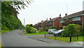
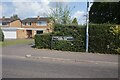
Suncliffe Drive, Kenilworth
Semi's on a cul-de-sac parallel to Warwick Road, to the south of the town centre.
Image: © Jonathan Billinger
Taken: 2 Jul 2008
0.20 miles
5
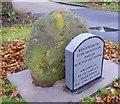
Old Boundary Marker by the former A429, Warwick Road, Kenilworth
Parish Boundary Marker by the UC (was A429), in parish of Kenilworth (Warwick District), Warwick Road, opposite the junction with Rouncil Lane on verge. Known as Betsy Smith's Grave.
Surveyed
Milestone Society National ID: WA_KENLEK01pb.
Image: © Milestone Society
Taken: Unknown
0.21 miles
6
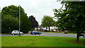
Junction of Rouncil Lane and Warwick Road
South of Kenilworth town centre.
Image: © Jonathan Billinger
Taken: 2 Jul 2008
0.21 miles
7
From country estate to housing estate
These mature trees are all that remains of the former Rouncil Towers estate, a Victorian mansion with extensive grounds in Kenilworth. The house is long demolished after ending its days as a motel, according to local residents. The grounds are now built over with housing. A photo of the mansion in its heyday is on the estimable Windows on Warwickshire website.
Image: © Colin Craig
Taken: 30 Jan 2009
0.24 miles
8
Vicarage Gardens off Rouncil Lane, Kenilworth
Image: © Ian S
Taken: 26 Jul 2021
0.24 miles