IMAGES TAKEN NEAR TO
Southbank Road, KENILWORTH, CV8 1LB
Introduction
This page details the photographs taken nearby to Southbank Road, CV8 1LB by members of the Geograph project.
The Geograph project started in 2005 with the aim of publishing, organising and preserving representative images for every square kilometre of Great Britain, Ireland and the Isle of Man.

There are currently over 7.5m images from over14,400 individuals and you can help contribute to the project by visiting https://www.geograph.org.uk
Image Map
Images are licensed for reuse under creativecommons.org/licenses/by-sa/2.0
Notes
- Clicking on the map will re-center to the selected point.
- The higher the marker number, the further away the image location is from the centre of the postcode.
Image Listing (354 Images Found)
Images are licensed for reuse under creativecommons.org/licenses/by-sa/2.0
Image
Details
Distance
1
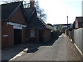
Driveway to the side of Wilton House, Southbank Road, Kenilworth
This driveway leads to the Senior Citizens Club and 18, 18a and 18b Southbank Road. All these properties are due to be demolished soon to make way for new retirement apartments.
Image: © John Brightley
Taken: 17 Apr 2010
0.01 miles
2
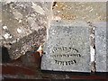
Wall coping, Wilton House, Southbank Road, Kenilworth
Wall to front forecourt.
Blue-brick coping with impressed stamp 'Stanley Bros. Midland Tile Works, Nuneaton'
Image: © John Brightley
Taken: 17 Apr 2010
0.03 miles
3

Posters on notice board, Wilton House, Kenilworth
Detail of building seen on Image]
Image: © John Brightley
Taken: 17 Apr 2010
0.03 miles
4
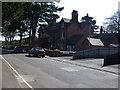
Wilton House, Southbank Road, Kenilworth
Originally the home of the Street family (see shared descriptions), and presently the offices of the town council and the local MP, Jeremy Wright. It is due to be demolished soon to make way for new apartments for the elderly.
Image: © John Brightley
Taken: 17 Apr 2010
0.03 miles
5
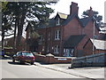
Wilton House, Southbank Road, Kenilworth
Image: © John Brightley
Taken: 17 Apr 2010
0.03 miles
6
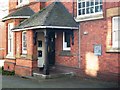
Porch detail, Wilton House, Southbank Road
Image: © John Brightley
Taken: 17 Apr 2010
0.03 miles
7
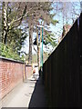
The Blundells footpath, Kenilworth
The section of the Blundells footpath between Abbey End car park and Southbank Road. The town council offices are behind the wall on the left.
Image: © John Brightley
Taken: 17 Apr 2010
0.03 miles
8
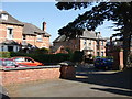
9 and 9a Southbank Road, Kenilworth
Seen from the forecourt of Wilton House.
Image: © John Brightley
Taken: 17 Apr 2010
0.04 miles
9

Senior Citizens Club, Abbey End, Kenilworth
The block that the club is a part of is actually called Wilton Court which, coincidentally or not, is otherwise made up of retirement flats. Abbey End, however, is the address given to it on its main online listing. This must be the name given to the road which runs alongside the long narrow car park its front door opens onto. On maps though, this road remains nameless; Abbey End is officially, by the looks of it, the major road running just West of here, parallel to the edge of the block pictured.
As nearby Coventry was so heavily bombed during the Second World War it is a little surprising that Kenilworth - which is located just two or three miles South - remained relatively so unscathed. There was only one major loss of life, which occurred very close to here, on the official bit of Abbey End. On either side of the section of that road North of today's roundabout, buildings that occupied the space now taken up by the Eastern bit of the Holiday Inn's car park and the pavement in front of the shops opposite were either destroyed or badly damaged by a German 'landmine' in 1940.
'Landmine' isn't an old word for a bomb, and it wasn't used back then with its modern meaning yet either. In fact it referred to something between the two: they were as big as bombs (the one that led to the 25 deaths in this instance is reported to have weighed half a tonne), but were unable to detonate properly at high speeds and so had parachutes attached to slow them down Theoretically they could be detonated using a timer but contact was the usual cause of explosion. According to local historian Robin Leach, who has undertaken a lot of research regarding this (a lot of which is available online on the Kenilworth-WW2 website), due to the lack of a crater and the minimal damage to the nearby road clocktower it is most likely that the 'mine' exploded after coming into contact with the roof of one of the properties on Abbey End. Poignantly, the last of the 25 dead is listed on today's memorial plaque as 'an unknown soul'.
Image: © Ian Dodds
Taken: 27 Dec 2023
0.04 miles
10
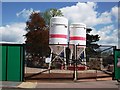
Dry Mortar silos on building site, Kenilworth
On the McCarthy & Stone site between Southbank Road and Abbey End.
My fellow contributor Richard Law, who works for Tarmac, tells me these silos contain a mix of sand and cement, premixed at the production plant to a specific recipe, and delivered to site to top up the silos as and when they run low, as building work proceeds. The advantages are that quality control lies with the producer, and that the brickies on site don't have to mix their own mortar, or have it delivered wet with the limited lifespan that wet mortar has. It's rapidly putting paid to the 'ready-mixed mortar' business in many places across the country.
Thanks to Richard for this information.
Image: © John Brightley
Taken: 12 May 2012
0.04 miles