IMAGES TAKEN NEAR TO
Chestnut Avenue, KENILWORTH, CV8 1GD
Introduction
This page details the photographs taken nearby to Chestnut Avenue, CV8 1GD by members of the Geograph project.
The Geograph project started in 2005 with the aim of publishing, organising and preserving representative images for every square kilometre of Great Britain, Ireland and the Isle of Man.

There are currently over 7.5m images from over14,400 individuals and you can help contribute to the project by visiting https://www.geograph.org.uk
Image Map (Loading...)


Getting Data...Please wait
Leaflet Map data © OpenStreetMap
Images are licensed for reuse under creativecommons.org/licenses/by-sa/2.0
Notes
- Clicking on the map will re-center to the selected point.
- The higher the marker number, the further away the image location is from the centre of the postcode.
Image Listing (23 Images Found)
Images are licensed for reuse under creativecommons.org/licenses/by-sa/2.0
Image
Details
Distance
1
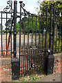
Ornate gate at entrance to Kenilworth Cemetery
Part of a set of four gates at the main cemetery entrance in Oaks Road.
They each have a letter in their lower panel with the set reading 'K U D C' for Kenilworth Urban District Council.
This is the right hand gate containing the letter 'C'.
Image: © John Brightley
Taken: 6 Jun 2010
0.05 miles
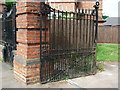
2
Gate at entrance to Kenilworth Cemetery
Part of a set of four gates at the main cemetery entrance in Oaks Road.
They each have a letter in their lower panel with the set reading 'K U D C' for Kenilworth Urban District Council.
This is the left hand gate containing the letter 'K', with the cemetery keeper's house seen behind.
Also see Image] and Image]
Image: © John Brightley
Taken: 6 Jun 2010
0.06 miles
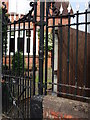
3
Gate at entrance to Kenilworth Cemetery
Part of a set of four gates at the main cemetery entrance in Oaks Road, with the central gates being for vehicles and the side gates for pedestrians.
They each have a letter in their lower panel with the set reading 'K U D C' for Kenilworth Urban District Council.
This is the second gate containing the letter 'U'.
Also see Image] and Image]
Image: © John Brightley
Taken: 6 Jun 2010
0.06 miles
4

Kenilworth Cemetery
Kenilworth's cemetery has an impressive display of crocuses.
Image: © Stephen McKay
Taken: 21 Mar 2010
0.12 miles
5
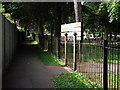
Footpath alongside Kenilworth cemetery
This footpath runs from Randall Road behind properties in St.Nicholas Avenue to Oaks Road, and along the boundary of the cemetery which can be seen on the right.It dates from well before the cemetery and the houses were constructed - it is shown on the 1888 OS map as part of a footpath running from the town centre to Goodrest Farm, Leek Wootton.
The section of the footpath south of Rounds Hill also still exists, but the central section disappeared with the building of the Dudley Road estate.
Image: © John Brightley
Taken: 6 Jun 2010
0.13 miles
6
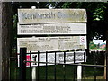
Sign at entrance to Kenilworth Cemetery
A close up of the sign seen in Image]
It is rather in need of adjustment and cleaning !
Image: © John Brightley
Taken: 6 Jun 2010
0.13 miles
7
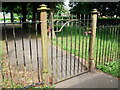
Gate at entrance to Kenilworth Cemetery
A close up of the gate seen in Image]
Image: © John Brightley
Taken: 6 Jun 2010
0.13 miles
8
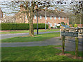
Beauchamp Road, Kenilworth
From the junction with Lancaster Place.
Image: © Stephen McKay
Taken: 1 Apr 2007
0.13 miles
9
Beauchamp Road, Kenilworth
From the junction with Dudley Road.
Image: © Stephen McKay
Taken: 1 Apr 2007
0.14 miles
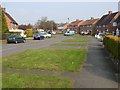
10
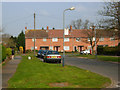
Beauchamp Road, Kenilworth
Looking towards the junction with Oaks Road. Sunday morning dog walkers are in evidence.
Image: © Stephen McKay
Taken: 1 Apr 2007
0.15 miles