IMAGES TAKEN NEAR TO
St. Johns Street, KENILWORTH, CV8 1FT
Introduction
This page details the photographs taken nearby to St. Johns Street, CV8 1FT by members of the Geograph project.
The Geograph project started in 2005 with the aim of publishing, organising and preserving representative images for every square kilometre of Great Britain, Ireland and the Isle of Man.

There are currently over 7.5m images from over14,400 individuals and you can help contribute to the project by visiting https://www.geograph.org.uk
Image Map (Loading...)


Getting Data...Please wait
Leaflet Map data © OpenStreetMap
Images are licensed for reuse under creativecommons.org/licenses/by-sa/2.0
Notes
- Clicking on the map will re-center to the selected point.
- The higher the marker number, the further away the image location is from the centre of the postcode.
Image Listing (84 Images Found)
Images are licensed for reuse under creativecommons.org/licenses/by-sa/2.0
Image
Details
Distance
1
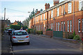
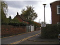
St Johns Street, Kenilworth
Short street of terraced houses leading to Roseland Road and Guy Road.
Image: © Stephen McKay
Taken: 27 Jan 2008
0.01 miles
2
White's Row, Kenilworth
For more details see Image]
Image: © John Brightley
Taken: 20 Apr 2004
0.04 miles
3
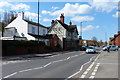
The Green Man in Kenilworth
A public house along Warwick Road.
Image: © Mat Fascione
Taken: 18 Apr 2015
0.05 miles
4
White's Row seen from near the junction with St.John's Street, Kenilworth
This section of road was constructed in the 1970's so that traffic for White's Row did not have to negotiate the narrow access/exit from Warwick Road seen on Image]
Image: © John Brightley
Taken: 20 Apr 2004
0.05 miles
5
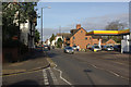
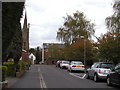
Warwick Road, Kenilworth
From the junction with St Johns Street. Warwick Road, the A452, is the main road through Kenilworth; this is looking towards the town centre. The pub on the immediate left is the Green Man.
Image: © Stephen McKay
Taken: 27 Jan 2008
0.05 miles
6
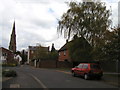
White's Row, Kenilworth
Looking eastwards towards St.John's church. The road straight ahead is the original line of the street, leading to Warwick Road. The tall Georgian houses in the background on the right of the street are 190-192 Warwick Road - a view of the front of these houses can be found at Image The section of White's Row that curves off to the left was built in the 1970's and can be seen at Image 1 White's Row, on the right, was demolished c.2005.
Image: © John Brightley
Taken: 20 Apr 2004
0.05 miles
7
1 White's Row, Kenilworth
This house was demolished c.2005 and two blocks of apartments now stand on the site. For a view of the rear, see Image]
Image: © John Brightley
Taken: 20 Apr 2004
0.05 miles
8
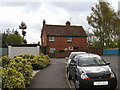
White's Row, Kenilworth
This is the section of road between 1 White's Row (the house in the background) and Warwick Road (off the photo to the left). Behind the wall on the left is the rear garden of 190 Warwick Road. The building on the right is Hazelwood House flats.
Image: © John Brightley
Taken: 20 Apr 2004
0.05 miles
9
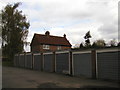
The rear of 1 White's Row, Kenilworth
Taken from the garage court of the adjacent flats.
1 White's Row was demolished c.2005 and two blocks of apartments were built on the site.
Image: © John Brightley
Taken: 20 Apr 2004
0.06 miles
10
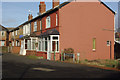
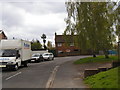
Roseland Road, Kenilworth
Roseland Road is a continuation of St Johns Street from the main Warwick Road. These houses are set at right angles to the road itself.
Image: © Stephen McKay
Taken: 27 Jan 2008
0.06 miles