IMAGES TAKEN NEAR TO
Brookside Avenue, KENILWORTH, CV8 1ET
Introduction
This page details the photographs taken nearby to Brookside Avenue, CV8 1ET by members of the Geograph project.
The Geograph project started in 2005 with the aim of publishing, organising and preserving representative images for every square kilometre of Great Britain, Ireland and the Isle of Man.

There are currently over 7.5m images from over14,400 individuals and you can help contribute to the project by visiting https://www.geograph.org.uk
Image Map (Loading...)


Getting Data...Please wait
Leaflet Map data © OpenStreetMap
Images are licensed for reuse under creativecommons.org/licenses/by-sa/2.0
Notes
- Clicking on the map will re-center to the selected point.
- The higher the marker number, the further away the image location is from the centre of the postcode.
Image Listing (144 Images Found)
Images are licensed for reuse under creativecommons.org/licenses/by-sa/2.0
Image
Details
Distance
1
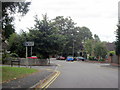
Entrance to Castle Farm Recreation Centre
Image: © Alex McGregor
Taken: 18 Jan 2012
0.12 miles
2
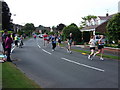
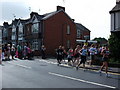
Brookside Avenue during the Two Castles Run 2010
The race comes from Fishponds Road (on the right) and enters the final half-kilometre before the finish at Kenilworth Castle.
Image: © John Brightley
Taken: 6 Jun 2010
0.12 miles
3
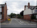
Brookside Avenue, Kenilworth
Viewed across the B4103 Borrowell Lane.
Image: © Jaggery
Taken: 8 Aug 2018
0.12 miles
4

Barrowfield Lane, Kenilworth
Viewed across the B4103.
Image: © Jaggery
Taken: 8 Aug 2018
0.12 miles
5
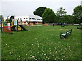
Castle Farm Recreation Centre
The centre is set in spacious playing fields which include a children's play area.
Image: © John Brightley
Taken: 26 May 2010
0.13 miles
6
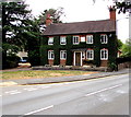
Old School House, Barrowfield Lane, Kenilworth
Viewed across the B4103 in August 2018. Now a private residence, originally the Parish School founded in 1724. Grade II listed in 1949.
Image: © Jaggery
Taken: 8 Aug 2018
0.13 miles
7
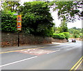
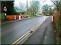
Warning signs alongside the B4103 Borrowell Lane, Kenilworth
Staggered minor crossroads 90 yards ahead. Pedestrian crossing 170 yards ahead.
Image: © Jaggery
Taken: 8 Aug 2018
0.13 miles
9
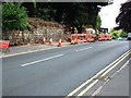
Sandstone retaining wall being rebuilt, Borrowell Lane
Boundary wall of apartments development adjacent to the Holiday Inn and opposite the junction with Barrowfield Lane.
Image: © John Brightley
Taken: 26 May 2010
0.13 miles
10
The corner of Brookside Avenue and Borrowell Lane, Kenilworth
Taken on the occasion of the Two Castles Run in 2010.
Having started from Warwick Castle and run through the back streets of Kenilworth, participants turn from Brookside Avenue into Borrowell Lane on the final leg up to the finish at Kenilworth Castle.
The row of houses in the background is Borrowell Terrace.
Image: © John Brightley
Taken: 6 Jun 2010
0.14 miles