IMAGES TAKEN NEAR TO
Bennetts Road, COVENTRY, CV7 8HX
Introduction
This page details the photographs taken nearby to Bennetts Road, CV7 8HX by members of the Geograph project.
The Geograph project started in 2005 with the aim of publishing, organising and preserving representative images for every square kilometre of Great Britain, Ireland and the Isle of Man.

There are currently over 7.5m images from over14,400 individuals and you can help contribute to the project by visiting https://www.geograph.org.uk
Image Map
Images are licensed for reuse under creativecommons.org/licenses/by-sa/2.0
Notes
- Clicking on the map will re-center to the selected point.
- The higher the marker number, the further away the image location is from the centre of the postcode.
Image Listing (25 Images Found)
Images are licensed for reuse under creativecommons.org/licenses/by-sa/2.0
Image
Details
Distance
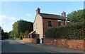
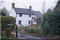
2
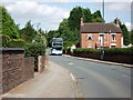
Bennetts Road, Keresley
The pair of semi-detached houses on the right are called Fieldside and Gipkaa. I get the feeling that the building was originally built as one detached house. Immediately to the right and beyond them is the Prologis Park distribution warehouse estate.
Travel Coventry bus Y825TOH is on service 36 Keresley (Beaumont Road) to Little Heath via Pool Meadow.
Image: © John Brightley
Taken: 31 Aug 2010
0.02 miles
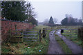
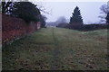
4
Footpath and farm track, Keresley
It was a hot, dusty, smoky summer evening, with a police helicopter hovering nearby and a fire engine passing along the road, possibly because of a grass fire in the neighbourhood.
Image: © A J Paxton
Taken: 8 Aug 2022
0.04 miles
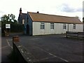
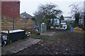
5
God shed & wood shed
In the foreground, Keresley United Reformed Church; behind it, a corrugated metal shed on an allotment site. Both sheds were once neighbours to Coventry Colliery Image], now an industrial and warehouse park.
Image: © A J Paxton
Taken: 29 Dec 2022
0.06 miles
6
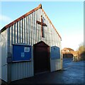
Keresley United Reformed Church, Bennetts Road
'Tin church' with walls of what might be corrugated aluminium, painted grey, on the main road of a former mining settlement on the edge of Coventry.
Image: © A J Paxton
Taken: 25 May 2021
0.06 miles
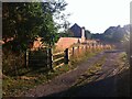
10
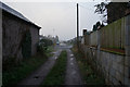
A farm track leading to Fivefield Road, Keresley
Image: © Ian S
Taken: 26 Dec 2013
0.12 miles