
IMAGES TAKEN NEAR TO
Gun Hill, COVENTRY, CV7 8HH
Introduction
This page details the photographs taken nearby to Gun Hill, CV7 8HH by members of the Geograph project.
The Geograph project started in 2005 with the aim of publishing, organising and preserving representative images for every square kilometre of Great Britain, Ireland and the Isle of Man.

There are currently over 7.5m images from over14,400 individuals and you can help contribute to the project by visiting https://www.geograph.org.uk
Image Map
Images are licensed for reuse under creativecommons.org/licenses/by-sa/2.0
Notes
- Clicking on the map will re-center to the selected point.
- The higher the marker number, the further away the image location is from the centre of the postcode.
Image Listing (4 Images Found)
Images are licensed for reuse under creativecommons.org/licenses/by-sa/2.0
Image
Details
Distance
1
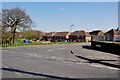
Sycamore Crescent taken from Gun Hill
Gun Hill is the name of the road just before it changes to Arley Lane.
Image: © Mick Malpass
Taken: 1 Apr 2012
0.02 miles
2
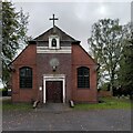
St Michael's Church, New Arley
The Arley Colliery Company began mining coal locally in 1905. In the 1920s it built a company village of six hundred houses, called New Arley, and, in 1928, a company church to serve it, the Church of England parish church of St Michael. The style could perhaps be called colliers' baroque. See the Victoria County History of Warwickshire, Vol. 6 pp8-12, which doesn't give the name of the architect https://www.british-history.ac.uk/vch/warks/vol6/pp8-12 .
Image: © A J Paxton
Taken: 24 Oct 2023
0.23 miles
3
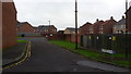
Stewart Court
Stewart Court is a small cul-de-sac in New Arley.
Image: © Peter Mackenzie
Taken: 23 Oct 2017
0.24 miles
4
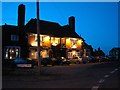
The Fir Tree, New Arley
A local pub for local people, and you can grab a curry until midnight!
Image: © Richard Harrison
Taken: 25 Oct 2005
0.25 miles