IMAGES TAKEN NEAR TO
Stonehouse Lane, COVENTRY, CV7 8GB
Introduction
This page details the photographs taken nearby to Stonehouse Lane, CV7 8GB by members of the Geograph project.
The Geograph project started in 2005 with the aim of publishing, organising and preserving representative images for every square kilometre of Great Britain, Ireland and the Isle of Man.

There are currently over 7.5m images from over14,400 individuals and you can help contribute to the project by visiting https://www.geograph.org.uk
Image Map
Images are licensed for reuse under creativecommons.org/licenses/by-sa/2.0
Notes
- Clicking on the map will re-center to the selected point.
- The higher the marker number, the further away the image location is from the centre of the postcode.
Image Listing (6 Images Found)
Images are licensed for reuse under creativecommons.org/licenses/by-sa/2.0
Image
Details
Distance
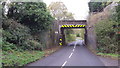
2
New Arley Bridge
The railway bridge over Spring Hill in New Arley looking Northwest
Image: © Graham Jones
Taken: 10 Jul 2017
0.22 miles
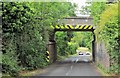
3
Railway bridge
The road goes under the Birmingham to Nuneaton railway line at this point.
Image: © Peter Mackenzie
Taken: 23 Oct 2017
0.22 miles
4
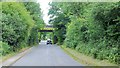
New Arley Bridge
The railway bridge over Station Road Near New Arley looking South-southeast
Image: © Graham Jones
Taken: 10 Jul 2017
0.23 miles
5
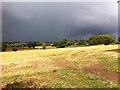
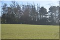
Slopes of Gun Hill and Spring Hill, New Arley
Image: © A J Paxton
Taken: 25 Aug 2018
0.24 miles
6
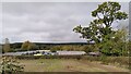
Arley industrial estate and Arley Wood
The industrial units are viewed from the path from Spring Hill to Daffern's Wood; they occupy the site of Arley Colliery, which closed in 1968. Arley Wood blankets the horizon. This ancient woodland was replanted with conifers in the 1960s, apparently to provide pit props for the mine; see Image
Image: © A J Paxton
Taken: 24 Oct 2023
0.25 miles