IMAGES TAKEN NEAR TO
The Laurels, COVENTRY, CV7 8FA
Introduction
This page details the photographs taken nearby to The Laurels, CV7 8FA by members of the Geograph project.
The Geograph project started in 2005 with the aim of publishing, organising and preserving representative images for every square kilometre of Great Britain, Ireland and the Isle of Man.

There are currently over 7.5m images from over14,400 individuals and you can help contribute to the project by visiting https://www.geograph.org.uk
Image Map
Images are licensed for reuse under creativecommons.org/licenses/by-sa/2.0
Notes
- Clicking on the map will re-center to the selected point.
- The higher the marker number, the further away the image location is from the centre of the postcode.
Image Listing (43 Images Found)
Images are licensed for reuse under creativecommons.org/licenses/by-sa/2.0
Image
Details
Distance
1
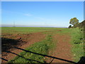
Corley summit
Corley is situated on a low ridge to the north of Coventry. The land visible in the foreground stands above the 180m contour and rises a little from the gateway, before dropping away again to the north. Not quite a Munroe but there's not much in the way of hills to the east from here to Norfolk.
Image: © E Gammie
Taken: 15 Nov 2010
0.06 miles
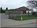
2
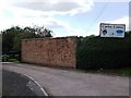
The entrance to Corley Centre, Church Lane, Corley
Corley Centre consists of a school and Coventry Autism Support Service (CASS).
The school caters for 72 students aged 11 - 16 with complex social and communication difficulties and associated learning difficulties. The school includes extended day and residential facilities. www.corleycentre.com
Image: © John Brightley
Taken: 31 Aug 2010
0.07 miles
3
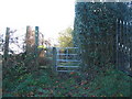
Footpath gateway, Church Lane
The modern kissing gate at the entrance to the public footpath running south towards Marsland Farm.
Image: © E Gammie
Taken: 15 Nov 2010
0.08 miles
4
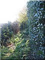
Public footpath off Church Lane
The beginning of the slightly overgrown footpath south from Church Lane.
Also: http://www.geograph.org.uk/photo/2162003
Image: © E Gammie
Taken: 15 Nov 2010
0.09 miles
5
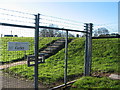
Caged trig point, Corley
This one isn't allowed to roam from the Severn Trent site on Church Lane.
Image: © E Gammie
Taken: 15 Nov 2010
0.09 miles
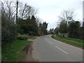
7
Church Lane, Corley
A small, trimmed godcake at the junction of a private drive with Church Lane.
Image: © E Gammie
Taken: 15 Nov 2010
0.10 miles
9
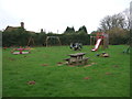
Children's playground, Corley
Beside Church Lane.
Image: © JThomas
Taken: 11 Mar 2017
0.12 miles
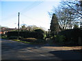
10
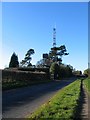
Church Lane, Corley
A communications mast towers above Scots pines and a water tank.
Image: © E Gammie
Taken: 15 Nov 2010
0.12 miles