IMAGES TAKEN NEAR TO
Broad Lane, COVENTRY, CV7 8EH
Introduction
This page details the photographs taken nearby to Broad Lane, CV7 8EH by members of the Geograph project.
The Geograph project started in 2005 with the aim of publishing, organising and preserving representative images for every square kilometre of Great Britain, Ireland and the Isle of Man.

There are currently over 7.5m images from over14,400 individuals and you can help contribute to the project by visiting https://www.geograph.org.uk
Image Map
Images are licensed for reuse under creativecommons.org/licenses/by-sa/2.0
Notes
- Clicking on the map will re-center to the selected point.
- The higher the marker number, the further away the image location is from the centre of the postcode.
Image Listing (4 Images Found)
Images are licensed for reuse under creativecommons.org/licenses/by-sa/2.0
Image
Details
Distance
1
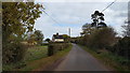
Detached country house
A detached house west of Fillongley.
Image: © Peter Mackenzie
Taken: 3 Nov 2018
0.02 miles
2
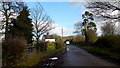
Broad Lane, approaching Chapel House
Land to the right is Fillongley Park.
Image: © Jonathan Billinger
Taken: 7 Feb 2017
0.03 miles
3
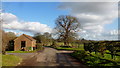
Broad Lane
Looking towards Fillongley by Stone House Farm.
Image: © Jonathan Billinger
Taken: 7 Feb 2017
0.20 miles
4
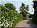
Broad Lane by Stone House Farm
Broad Lane hardly lives up to its name, and is also very twisty near Stone House Farm.
Image: © Andrew Hill
Taken: 30 Apr 2011
0.23 miles