IMAGES TAKEN NEAR TO
Church Lane, COVENTRY, CV7 8AS
Introduction
This page details the photographs taken nearby to Church Lane, CV7 8AS by members of the Geograph project.
The Geograph project started in 2005 with the aim of publishing, organising and preserving representative images for every square kilometre of Great Britain, Ireland and the Isle of Man.

There are currently over 7.5m images from over14,400 individuals and you can help contribute to the project by visiting https://www.geograph.org.uk
Image Map
Images are licensed for reuse under creativecommons.org/licenses/by-sa/2.0
Notes
- Clicking on the map will re-center to the selected point.
- The higher the marker number, the further away the image location is from the centre of the postcode.
Image Listing (7 Images Found)
Images are licensed for reuse under creativecommons.org/licenses/by-sa/2.0
Image
Details
Distance
1
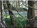
Bluebells in Daddley's Wood, Wall Hill
There is no public access to the wood, but it can be viewed from the field path which runs alongside it.
Image: © A J Paxton
Taken: 7 May 2021
0.16 miles
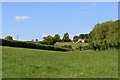
2

Farmland near Corley
The tower visible on the horizon is the former Massey Ferguson office block on Banner Lane, Coventry (SP2779).
Image: © E Gammie
Taken: 15 Nov 2010
0.18 miles
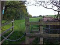
3

Lane to Marsland Farm
Overlooking farmland to the north west of Coventry, from the end of the section marked as a permissive route on OS maps.
In August: http://www.geograph.org.uk/photo/2054053
Image: © E Gammie
Taken: 15 Nov 2010
0.18 miles
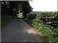
4
Path along west side of Daddley's Wood, Wall Hill
Seen from the kissing gate to the north, looking south towards Wall Hill and Hawkes End.
Image: © A J Paxton
Taken: 7 May 2021
0.20 miles
6

Oak by the lane to Marsland Farm
By the section of the lane marked as a permissive route on OS maps. Overlooking farmland to the northwest of Coventry.
Image: © E Gammie
Taken: 15 Nov 2010
0.21 miles
7
The lane to Marslands Farm, Corley
This is a very tranquil and unspoilt lane. According to the OS 1:25,000 map, the lane is a public highway up to this point. The tarmac surface is unchanged past the gate though, so I wonder whether it is public highway for a few hundred yards further. I expect not many people come even this far, as no other rights of way lead on from this point.
Image: © John Brightley
Taken: 31 Aug 2010
0.21 miles