IMAGES TAKEN NEAR TO
Fillongley Road, COVENTRY, CV7 7HU
Introduction
This page details the photographs taken nearby to Fillongley Road, CV7 7HU by members of the Geograph project.
The Geograph project started in 2005 with the aim of publishing, organising and preserving representative images for every square kilometre of Great Britain, Ireland and the Isle of Man.

There are currently over 7.5m images from over14,400 individuals and you can help contribute to the project by visiting https://www.geograph.org.uk
Image Map
Images are licensed for reuse under creativecommons.org/licenses/by-sa/2.0
Notes
- Clicking on the map will re-center to the selected point.
- The higher the marker number, the further away the image location is from the centre of the postcode.
Image Listing (23 Images Found)
Images are licensed for reuse under creativecommons.org/licenses/by-sa/2.0
Image
Details
Distance
1
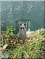
OS flush bracket S3086
S3086 is set into the side of the Hollyberry trig, and was originally levelled at 181.099m above Ordnance Datum Newlyn in 1958. There is a belief that the trig may have been moved along the hedge since then, so that height is not totally reliable, but it's good enough for most people's purposes on a day to day basis.
Image: © Richard Law
Taken: 15 Feb 2018
0.05 miles
2
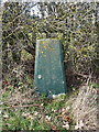
Hollyberry End trig point
Painted green by a trig-bagging visitor in 2009, and probably relocated a few yards to the SW of its original position.
Image: © Richard Law
Taken: 15 Feb 2018
0.05 miles
3
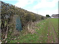
Hollyberry End trig
Lurking in a hedge just southwest of Wood End farm, Hollyberry trig is given a height of 181.1m above sea level.
Image: © Richard Law
Taken: 15 Feb 2018
0.06 miles
5
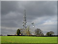
Communication masts by Fillongley Road
By Wood End Farm
Image: © John Winterbottom
Taken: 25 Jan 2006
0.12 miles
7
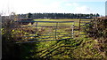
Arable and woodland, 2
View of 180 degree view to camera position in Image showing a cereal crop and coniferous Church Wood.
Image: © Jonathan Billinger
Taken: 7 Feb 2017
0.14 miles
9
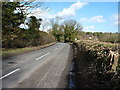
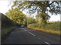
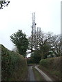
The B4102 Fillongley Road near Wood End Farm
Image: © Richard Law
Taken: 15 Feb 2018
0.15 miles
10
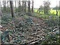
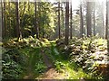
Close Wood
Woodland maintenance aftermath left for nature to clear up
Image: © Telf
Taken: Unknown
0.16 miles