IMAGES TAKEN NEAR TO
Kinwalsey Lane, COVENTRY, CV7 7HT
Introduction
This page details the photographs taken nearby to Kinwalsey Lane, CV7 7HT by members of the Geograph project.
The Geograph project started in 2005 with the aim of publishing, organising and preserving representative images for every square kilometre of Great Britain, Ireland and the Isle of Man.

There are currently over 7.5m images from over14,400 individuals and you can help contribute to the project by visiting https://www.geograph.org.uk
Image Map
Images are licensed for reuse under creativecommons.org/licenses/by-sa/2.0
Notes
- Clicking on the map will re-center to the selected point.
- The higher the marker number, the further away the image location is from the centre of the postcode.
Image Listing (10 Images Found)
Images are licensed for reuse under creativecommons.org/licenses/by-sa/2.0
Image
Details
Distance
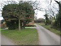
1
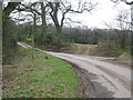
And Another Footpath
No through road off to right (to Warren Farm), and Kinwalsey Lane ahead. Footpath to left takes an easterly ascent back towards Hayes Hall Farm
Image: © Michael Westley
Taken: 12 Mar 2011
0.03 miles
2
All To Yourselves - City View
Distant view of Chelmsley Wood and Birmingham from Kinwalsey Lane
Image: © Michael Westley
Taken: 2 Apr 2023
0.03 miles
3
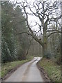
Kinwalsey Lane
Country lane, in direction of Close Wood and Boultbee's Wood
Image: © Michael Westley
Taken: 12 Mar 2011
0.08 miles
4
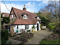
Hill Wood Cottage farmhouse
Although clearly much extended over the years, the core of the housee is a 17th century, timber framed cottage which was Grade II listed https://www.britishlistedbuildings.co.uk/101076748-hill-wood-cottage-farmhouse-meriden#.WorNSfnFKM8 in 1976. Photo taken by kind permission of the owner.
Image: © Richard Law
Taken: 15 Feb 2018
0.10 miles
5
Kinwalsey Lane
Quiet country lanes, unclassified road ahead (not for through traffic), a footpath goes across fields to the right
Image: © Michael Westley
Taken: 12 Mar 2011
0.11 miles
6
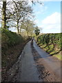
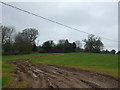
Mucky lane south of Rutters Hall
Not long after a couple of wet days, and the lane is somewhat filthy.
Image: © Richard Law
Taken: 15 Feb 2018
0.17 miles
7
Close Wood forestry access
Approach from Kinwalsey Lane
Image: © Michael Westley
Taken: 12 Mar 2011
0.18 miles
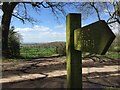
8
You Can't Beat a Bit O' Bulley
Permissive path / right of way across fields close to Kinwalsey
Image: © Michael Westley
Taken: 12 Mar 2011
0.22 miles
9
Muddy farm track, Kinwalsey
Off Kinwalsey Lane.
Image: © JThomas
Taken: 11 Mar 2017
0.23 miles
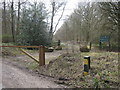
10
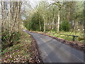
Kinwalsey Lane in Boultbee's Wood
The lane runs generally northwards from the B4102 to the settlement of Kinwalsey. The signs on the gate into Boultbee's Wood (and similar ones a little further on into Close Wood on the left) suggest that public access is not encouraged.
Image: © Richard Law
Taken: 15 Feb 2018
0.23 miles