IMAGES TAKEN NEAR TO
Townley Walk, COVENTRY, CV6 7PP
Introduction
This page details the photographs taken nearby to Townley Walk, CV6 7PP by members of the Geograph project.
The Geograph project started in 2005 with the aim of publishing, organising and preserving representative images for every square kilometre of Great Britain, Ireland and the Isle of Man.

There are currently over 7.5m images from over14,400 individuals and you can help contribute to the project by visiting https://www.geograph.org.uk
Image Map
Images are licensed for reuse under creativecommons.org/licenses/by-sa/2.0
Notes
- Clicking on the map will re-center to the selected point.
- The higher the marker number, the further away the image location is from the centre of the postcode.
Image Listing (81 Images Found)
Images are licensed for reuse under creativecommons.org/licenses/by-sa/2.0
Image
Details
Distance
1
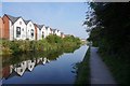
Houses overlooking Coventry Canal at Little Heath
Image: © Ian S
Taken: 27 Aug 2019
0.01 miles
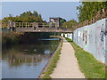
2
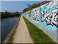
Graffiti along the Coventry Canal
The Little Heath Industrial Estate is to the right of the fence.
Image: © Mat Fascione
Taken: 11 Sep 2014
0.02 miles
3
![A stroll along the Coventry Canal to Hawkesbury Junction [32]](https://s0.geograph.org.uk/geophotos/07/12/19/7121952_84fce4f7_120x120.jpg)
A stroll along the Coventry Canal to Hawkesbury Junction [32]
Recently constructed housing seen across the canal.
The narrow canal was built to connect the city of Coventry with the Trent & Mersey Canal, some 38 miles distant, to exploit the Warwickshire coalfields. Construction of the canal took 20 years before it was complete in 1769. The canal between the basin in Coventry and Hawkesbury junction was made a conservation area in 2012.
Image: © Michael Dibb
Taken: 23 Sep 2021
0.03 miles
4
Coventry Canal, Little Heath
An industrial stretch of canal: the works on the left, now derelict, was once Courtaulds' acetate plant - a major local employer.
Image: © Stephen McKay
Taken: 19 Oct 2008
0.04 miles
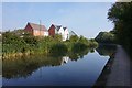
5
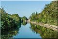
Coventry Canal
Looking along the Coventry Canal as it runs alongside Old Church Road.
Image: © Ian Capper
Taken: 23 Sep 2021
0.04 miles
6
![A stroll along the Coventry Canal to Hawkesbury Junction [33]](https://s2.geograph.org.uk/geophotos/07/12/19/7121954_7c5ff283_120x120.jpg)
A stroll along the Coventry Canal to Hawkesbury Junction [33]
Some new housing and a somewhat older industrial building. This site was formerly part of the Courtaulds Acetate works.
The narrow canal was built to connect the city of Coventry with the Trent & Mersey Canal, some 38 miles distant, to exploit the Warwickshire coalfields. Construction of the canal took 20 years before it was complete in 1769. The canal between the basin in Coventry and Hawkesbury junction was made a conservation area in 2012.
Image: © Michael Dibb
Taken: 23 Sep 2021
0.06 miles
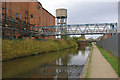
7
Bridge 7A: Little Heath Factory Footbridge
Crossing the Coventry Canal in the Little Heath area of Coventry.
Image: © Mat Fascione
Taken: 11 Sep 2014
0.07 miles
8
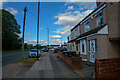
Coventry : Old Church Road B4082
Looking along Old Church Road.
Image: © Lewis Clarke
Taken: 25 Sep 2021
0.07 miles
9
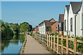
Philips Walk and Cordin View
Housing alongside the Coventry Canal dating from 2018 and 2019 respectively, built on the site of the former Courtaulds Acetate works.
Image: © Ian Capper
Taken: 23 Sep 2021
0.07 miles
10
Houses overlooking Coventry Canal at Little Heath
Image: © Ian S
Taken: 27 Aug 2019
0.09 miles