IMAGES TAKEN NEAR TO
Heddle Grove, COVENTRY, CV6 7LN
Introduction
This page details the photographs taken nearby to Heddle Grove, CV6 7LN by members of the Geograph project.
The Geograph project started in 2005 with the aim of publishing, organising and preserving representative images for every square kilometre of Great Britain, Ireland and the Isle of Man.

There are currently over 7.5m images from over14,400 individuals and you can help contribute to the project by visiting https://www.geograph.org.uk
Image Map
Images are licensed for reuse under creativecommons.org/licenses/by-sa/2.0
Notes
- Clicking on the map will re-center to the selected point.
- The higher the marker number, the further away the image location is from the centre of the postcode.
Image Listing (15 Images Found)
Images are licensed for reuse under creativecommons.org/licenses/by-sa/2.0
Image
Details
Distance
1
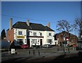
Coventry-The Weaver's Arms
Public House in Bell Green Road.
Image: © Ian Rob
Taken: 9 Jan 2011
0.14 miles
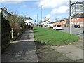
2
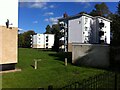
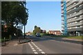
Tower Blocks, Purcell Road, Courthouse Green
Three four-storey blocks of an S-curved row of nine can be seen here; for a view from the other end of the row see Image The blocks overlook the River Sowe and its meadows. Purcell Road is named after the English composer Henry Purcell of the baroque era; it adjoins other musical streets named after Elgar, Sullivan and Parry.
Image: © A J Paxton
Taken: 8 Oct 2022
0.16 miles
3
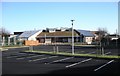
Coventry-Courthouse Green Primary School
The new school standing on the site of the old which was demolished last year. It seems to have turf on the roof?
Image: © Ian Rob
Taken: 9 Jan 2011
0.17 miles
6
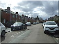
Dame Agnes Grove, Coventry
Looking south west.
Image: © JThomas
Taken: 4 Mar 2017
0.22 miles
7
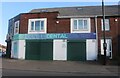
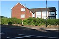
Gentle Dental Centre on Bell Green Road
Image: © David Howard
Taken: 21 May 2023
0.22 miles
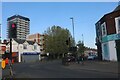
8
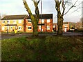
Bellview, Bell Green, no Bell
The modern Coventry district of Bell Green grew from a hamlet of that name in the parish of Foleshill, a district of farm workers, coal miners and ribbon weavers. Houses clustered around a green where Church Road (now Old Church Road), Bell Green Road, Hall Green Road and Henley Road met. They included the Bell pub, which gave its name to the settlement. The Bell was known as a place where entertainers stayed while performing at the Coventry Theatre. It was demolished in the 1960s. A street of houses, Bellview Way, was later built on and around the site. It can be seen here, viewed from the green, now a busy traffic roundabout, in the wan sunlight of Christmas Eve 2022.
See David Fry & Albert Smith, The Coventry we have Lost: Forgotten Foleshill, Simanda Press, 2018, p63 & p68.
Image: © A J Paxton
Taken: 24 Dec 2022
0.23 miles
10
Henley Road at the junction of Bell Green Road
Image: © David Howard
Taken: 21 May 2023
0.24 miles