IMAGES TAKEN NEAR TO
Bell Green Road, COVENTRY, CV6 7HB
Introduction
This page details the photographs taken nearby to Bell Green Road, CV6 7HB by members of the Geograph project.
The Geograph project started in 2005 with the aim of publishing, organising and preserving representative images for every square kilometre of Great Britain, Ireland and the Isle of Man.

There are currently over 7.5m images from over14,400 individuals and you can help contribute to the project by visiting https://www.geograph.org.uk
Image Map
Images are licensed for reuse under creativecommons.org/licenses/by-sa/2.0
Notes
- Clicking on the map will re-center to the selected point.
- The higher the marker number, the further away the image location is from the centre of the postcode.
Image Listing (55 Images Found)
Images are licensed for reuse under creativecommons.org/licenses/by-sa/2.0
Image
Details
Distance
1
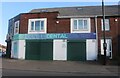
Gentle Dental Centre on Bell Green Road
Image: © David Howard
Taken: 21 May 2023
0.02 miles
2
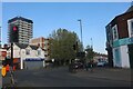
Henley Road at the junction of Bell Green Road
Image: © David Howard
Taken: 21 May 2023
0.03 miles
3
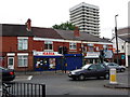
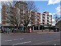
The junction of Hall Green Road, Bell Green Road and Henley Road, Bell Green
The centre of Bell Green - always a busy road junction.
The Polish delicatessen 'Kasia' is relatively new - previously there was a butcher's here for many years. The house next door to the left housed a barber's shop on the ground floor for many years.
The tower block behind is Dewis House, part of the Riley Square development.
Image: © John Brightley
Taken: 25 May 2010
0.04 miles
4
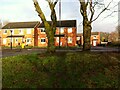
Bellview, Bell Green, no Bell
The modern Coventry district of Bell Green grew from a hamlet of that name in the parish of Foleshill, a district of farm workers, coal miners and ribbon weavers. Houses clustered around a green where Church Road (now Old Church Road), Bell Green Road, Hall Green Road and Henley Road met. They included the Bell pub, which gave its name to the settlement. The Bell was known as a place where entertainers stayed while performing at the Coventry Theatre. It was demolished in the 1960s. A street of houses, Bellview Way, was later built on and around the site. It can be seen here, viewed from the green, now a busy traffic roundabout, in the wan sunlight of Christmas Eve 2022.
See David Fry & Albert Smith, The Coventry we have Lost: Forgotten Foleshill, Simanda Press, 2018, p63 & p68.
Image: © A J Paxton
Taken: 24 Dec 2022
0.05 miles
5

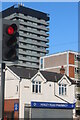
Flats at Riley Square facing Henley Road, Bell Green, north Coventry
This block is believed to be called Joseph Latham House. Looming above it is the central tower block at Riley Square. At ground level there's a glimpse of the shopping precinct in the square.
Image: © Robin Stott
Taken: 11 Jul 2016
0.05 miles
6
Entrance to Riley Square from Henley Road, Bell Green
Riley Square is a shopping centre in Bell Green, on the edge of the largest concentration of council housing built in Coventry after 1945. It is also a housing estate, with flats built over the shops. It was constructed between 1957 and 1965 to the designs of the City Architect's Department under Arthur Ling. His team included Wilfred Burns, who advocated 'neighbourhood centres' of 100-150 shops. Riley Square was the only such centre built on this scale in the city. It is named after the local cycle and motor manufacturer William Riley, who is commemorated by a mural Image
Four four-storey council housing blocks were erected, straddling the pedestrian entrances to the square on 'pilotis' or pillars, with shops on the ground floor to either side. Facing onto Henley Road, the main entrance to the square, is Joseph Latham House, the shortest of the four blocks. A 17-storey block of flats, Dewis House, also with shops underneath, was built at the centre of the square, and can be seen towering above Joseph Latham House in the photo. For more information see Coventry: The Making of a Modern City 1939-1973, by J Gould & C Gould, published by Historic England in 2016 and available at the Historic England site https://historicengland.org.uk/images-books/publications/coventry-making-of-modern-city-1939-73/ .
Local people often date the decline of Riley Square to the year 2000, when the branch of Lloyds Bank closed. The square has struggled to compete with more modern suburban shopping malls, superstores and retail parks with better car parking. A redevelopment proposal received planning permission in 2022. It includes the demolition of Joseph Latham House to open up the approach from Henley Road and make the site more welcoming. See this Coventry Telegraph article, which also includes archive photos of Riley Square https://www.coventrytelegraph.net/news/history/history-riley-square-coventrys-iconic-19304017 .
Image: © A J Paxton
Taken: 25 Mar 2023
0.06 miles
8
Local boy who founded Riley Motors
William 'Billy' Riley is remembered by a mural at the entrance to the Coventry shopping precinct which bears his name, Riley Square. See the mural while you can; it may not survive the proposed demolition of Joseph Latham House, underneath which it sits. For more information see Image] and Image], which show the two panels of the mural in more detail.
Image: © A J Paxton
Taken: 26 Dec 2022
0.06 miles
9
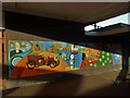
Riley mural, Riley Square, Bell Green
A pair of brightly-coloured murals enlivens the gloomy entrance to the Riley Square shopping precinct from Henley Road. They are painted on the walls of Joseph Latham House, the block of flats which straddles the entrance. This photo shows half of the mural on the northwest side.
Riley Square is named after William or Billy Riley, the local boy who gave his name to Riley Motors and its cars. His son Percy built his first car in 1898 at the age of 16, working in secret because his father, a bicycle manufacturer, did not approve. It was not until 1907 that Percy and his brothers convinced their father to switch from making bicycles and motorcycles to automobiles. The company was bought by Morris Motors in 1938. See Wikipedia https://en.wikipedia.org/wiki/Riley_Motor and Graces Guide https://www.gracesguide.co.uk/Riley .
In the background can be seen other scenes of Bell Green life. The pub is the Rose & Crown, which still stands at the top of Aldermans Green Road, although it was rebuilt in the 1950s. To the right, a double-decker tram with an advertisement for Lifebuoy soap descends Bell Green Road towards Coventry city centre.
The other half of the mural can be seen here Image
Image: © A J Paxton
Taken: 12 Sep 2022
0.06 miles
10
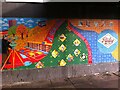
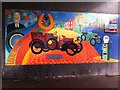
Riley Square mural, Bell Green
This is the right-hand side of the Riley mural Image] and shows the building, in the 1960s, of the square which bears the name of the motor company. A surveyor measures angles with a theodolite. To his right can be seen part of the finished development, with a five-storey block of flats overlooking shop units. The diamond insets on the green ground show various traders occupying these shops, which by the time this photograph was taken (2022) were mostly shuttered and empty. To the right can be seen the Riley motors badge. The pattern of circles and semicircles alongside appears in relief on one of the buildings of Riley Square, now a Farmfoods shop.
Image: © A J Paxton
Taken: 12 Sep 2022
0.06 miles