IMAGES TAKEN NEAR TO
Albert Fearn Gardens, COVENTRY, CV6 7DX
Introduction
This page details the photographs taken nearby to Albert Fearn Gardens, CV6 7DX by members of the Geograph project.
The Geograph project started in 2005 with the aim of publishing, organising and preserving representative images for every square kilometre of Great Britain, Ireland and the Isle of Man.

There are currently over 7.5m images from over14,400 individuals and you can help contribute to the project by visiting https://www.geograph.org.uk
Image Map
Images are licensed for reuse under creativecommons.org/licenses/by-sa/2.0
Notes
- Clicking on the map will re-center to the selected point.
- The higher the marker number, the further away the image location is from the centre of the postcode.
Image Listing (96 Images Found)
Images are licensed for reuse under creativecommons.org/licenses/by-sa/2.0
Image
Details
Distance
1
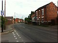
Old Church Road, Foleshill, looking towards Bell Green
On the OS 6 inch map, 1888-1913, this first stretch of the road, as far as the canal, is named Chapel Lane, presumably after the Congregational Chapel (now the United Reformed Church); after the canal bridge it is marked as Church Lane. At that time the area was still semi-rural. https://maps.nls.uk/geo/explore/side-by-side/#zoom=14&lat=52.43744&lon=-1.48469&layers=6&right=ESRIWorld
Image: © A J Paxton
Taken: 31 Jul 2021
0.03 miles
2
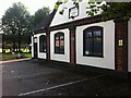
Former Congregational church school, Foleshill, Coventry
A Congregational school building on Old Church Road, now part of Foleshill United Reformed Church, which has a larger building on the same site. The church was founded as a Congregational chapel in 1795. The schoolhouse bears the inscription 'British School 1848' on the gable end visible in the photo. Though situated at a busy road junction, the church has an extensive and secluded churchyard, visible at the rear.
Image: © A J Paxton
Taken: 31 Jul 2021
0.06 miles
3
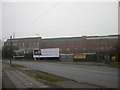
Coventry - Little Heath
Looking from Old Church Road to factory buildings.
Image: © Ian Rob
Taken: 19 Feb 2006
0.06 miles
4
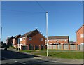
Coventry - Little Heath
Recreating this 'First' for the square https://www.geograph.org.uk/photo/124734 . A best guess at the right location, as none of the features in the original exist. New housing has completely taken over the former industrial development; only the original title of the picture remains!
Image: © Alan Murray-Rust
Taken: 23 Sep 2021
0.06 miles
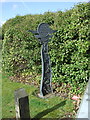
5
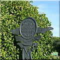
Canal Entry Marker, Little Heath Bridge
One of a series of markers associated with the Coventry Canal Art Trail, each with a different reminiscence from a local resident. This is on the west side of the bridge.
Image: © Alan Murray-Rust
Taken: 23 Sep 2021
0.08 miles
6
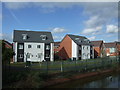
New housing beside the Coventry Canal
View from the bridge on Old Church Road.
Image: © JThomas
Taken: 4 Mar 2017
0.08 miles
7
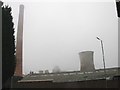
Coventry - Little Heath
Chimney and cooling tower from old factory shrouded in mist. Taken from just west of Coventry Canal.
Image: © Ian Rob
Taken: 19 Feb 2006
0.08 miles
9
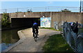
Bridge 7: Old Church Road Bridge
Crossing the Coventry Canal in the Little Heath area of Coventry.
Image: © Mat Fascione
Taken: 11 Sep 2014
0.09 miles
10
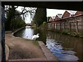
Coventry Canal, looking south from under the Old Church Road bridge, Foleshill
Image: © A J Paxton
Taken: 21 Mar 2019
0.09 miles