IMAGES TAKEN NEAR TO
Mottram Close, CV6 6QN
Introduction
This page details the photographs taken nearby to Mottram Close, CV6 6QN by members of the Geograph project.
The Geograph project started in 2005 with the aim of publishing, organising and preserving representative images for every square kilometre of Great Britain, Ireland and the Isle of Man.

There are currently over 7.5m images from over14,400 individuals and you can help contribute to the project by visiting https://www.geograph.org.uk
Image Map
Images are licensed for reuse under creativecommons.org/licenses/by-sa/2.0
Notes
- Clicking on the map will re-center to the selected point.
- The higher the marker number, the further away the image location is from the centre of the postcode.
Image Listing (10 Images Found)
Images are licensed for reuse under creativecommons.org/licenses/by-sa/2.0
Image
Details
Distance
1

Pond at dusk, Hawkesbury, Bedworth
Pond on a patch of open ground between the Bayton Road industrial estate and the Coventry Canal, which has several pits and depressions, quite possibly the result of mining subsidence.
Image: © A J Paxton
Taken: 13 Oct 2019
0.10 miles
2
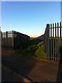
Footpath from Bayton Road industrial estate to pedestrian tunnel under the railway
The path is bounded by metal fencing on both sides. It seems an odd place to put a path, were it not for the tunnel at the end. The OS Six Inch Map, 1888-1913 Series, shows a settlement here, Little Bayton, off Sydnall Lane (the modern Bayton Road), large enough to support a chapel, the houses along a street where this path now runs. There is no sign of Little Bayton today. https://maps.nls.uk/geo/explore/side-by-side/#zoom=16&lat=52.46645&lon=-1.47469&layers=6&right=OSAPI
Image: © A J Paxton
Taken: 30 May 2021
0.16 miles
3
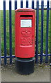
Elizabeth II postbox on Bayton Road, Exhall
Image: © JThomas
Taken: 11 Mar 2017
0.16 miles
4
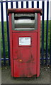
Elizabeth II postbox (business box) on Bayton Road, Exhall
Image: © JThomas
Taken: 11 Mar 2017
0.16 miles
5
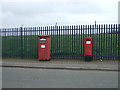
Elizabeth II postboxes on Bayton Road, Exhall
Postbox No. CV7 198 (business box).
Postbox No. CV7 377.
Image: © JThomas
Taken: 11 Mar 2017
0.16 miles
6
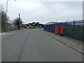
Bayton Road, Exhall
Looking east showing position of Postbox No. CV7 198 (business box) and Postbox No. CV7 377.
See Image] for Postbox No. CV7 377.
See Image] for Postbox No. CV7 198.
Image: © JThomas
Taken: 11 Mar 2017
0.16 miles
7
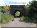
Bridge and Path
Just through this railway bridge a footpath leads over the Coventry Canal to Hawkesbury.
Image: © Michael Patterson
Taken: 3 Jul 2006
0.16 miles
8
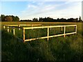
A fence around a hole
Fenced-off hole on a patch of open ground between Bayton Road industrial estate and Hawkesbury, Bedworth. At least three more sites in this area have been similarly fenced off and are visible in the distance on this photo. They are presumably subsidence resulting from coal mining, which was carried out in Bedworth until 1982. Other holes in the vicinity have developed into flashes, ponds resulting from subsidence.
Image: © A J Paxton
Taken: 30 May 2021
0.16 miles
10
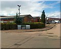
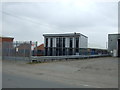
Industrial Estate, Brindley Road, Bedworth
Image: © Alex McGregor
Taken: 7 Jun 2011
0.20 miles