1
Former farm buildings, Lythalls Lane, Coventry
Buildings of a farm, marked on the OS 6-inch map of 1888-1913 as Hollybank Farm, now deep in the built-up area of Coventry. https://maps.nls.uk/geo/explore/side-by-side/#zoom=16&lat=52.43930&lon=-1.49834&layers=6&right=OSAPI The farmhouse is still used as housing while the building beyond it is part of a motor business.
Image: © A J Paxton
Taken: 21 May 2021
0.01 miles
2
An unexpected watering hole
In among Coventry Centreless Grinding and suchlike workshops on the Lythalls Lane Industrial Estate can be found a craft brewery with a tap room, conveniently near to the football and rugby stadium. Its orange sign can be seen at the left hand side of this photo, on the last but one unit; it was founded in 2011 and its website is here https://www.byattsbrewery.co.uk/about/ .
The industrial estate stands on the site of a tram depot and the Foleshill Union Workhouse, as can be seen on the OS Six Inch 1888-1913 Series map https://maps.nls.uk/geo/explore/side-by-side/#zoom=16&lat=52.44003&lon=-1.49592&layers=6&right=osm
Image: © A J Paxton
Taken: 14 Jul 2022
0.08 miles
3
Hindu temple, Lythalls Lane, Coventry
Eellakkanthan Thirukkovil is a temple dedicated to Murugan (Kartikeya), a god of partcular importance to Tamil communities. https://www.ishtadevata.com/temple/eellakkanthan-thirukkovil-coventry-warwickshire/ https://en.wikipedia.org/wiki/Kartikeya
Image: © A J Paxton
Taken: 21 May 2021
0.09 miles
4
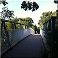
Footbridge from Foleshill to Holbrooks
This metal footbridge crosses the A444 Jimmy Hill Way, formerly known as Phoenix Way, which is the main road northwards out of Coventry and was constructed in the 1990s. The footbridge connects Beresford Road in Foleshill with Holbrook Primary School and with Lythalls Lane via Copper Beech Close.
Image: © A J Paxton
Taken: 14 Jul 2022
0.10 miles
5
Petrol station on Foleshill Road
The picture shows the Texaco petrol station on Foleshill road, Coventry.
Image: © Peter Mackenzie
Taken: 3 Jan 2017
0.10 miles
6
A444, Footbridge near Holbrook Primary School
Image: © David Dixon
Taken: 5 Aug 2013
0.10 miles
7
Portable toilets in Elliott Loohire depot
Image: © chris almond
Taken: 26 Sep 2008
0.11 miles
8
Shops on Foleshill Road
Image: © Steve Daniels
Taken: 23 Mar 2019
0.13 miles
9
Blue Ribbon Roundabout, Foleshill, Coventry
The Blue Ribbon roundabout forms the junction between Foleshill Road, the historic main road north out of Coventry, and the A444 Jimmy Hill Way, the modern dual carriageway out of the city, which was built in the 1990s as Phoenix Way. It was renamed after the death of Jimmy Hill, the former Coventry City FC manager, in 2015. Though both are north-south roads, the S-curve of Jimmy Hill Way, which is in part built along the route of a railway, causes it to cross the straighter Foleshill Road almost at a right angle at this roundabout.
The blue ribbon sculpture alludes to the silk ribbon weaving industry, the dominant trade in Coventry in the 18th and 19th centuries until around 1860. Blue dye made from woad, a plant related to indigo, was also strongly associated with Coventry, 'as true as Coventry blue'.
The northern continuation of Foleshill Road can be seen to the right of the picture.
Image: © A J Paxton
Taken: 31 Jul 2021
0.14 miles
10
The Blue Ribbon Roundabout viewed from the north
This distinctive Coventry landmark dates from 1997 and forms the junction of the two main road routes north out of the city: the historic Foleshill Road and the 1990s dual carriageway of the A444, originally named Phoenix Way and since renamed Jimmy Hill Way, after the former Coventry City football club manager.
This area of Foleshill was once known as Parting of the Heaths and was a centre of cottage industry weaving ribbons. The sculpture was the idea of Will Farrell, then a student at the local Foxford School, and alludes to the historic textile industry and to the blue of woad dye, which has become the colour associated with Coventry. See this article in the Coventry Telegraph, '25 years of Coventry's most famous roundabout' (5th March 2022) https://www.coventrytelegraph.net/news/coventry-news/25-years-coventrys-most-famous-23290921 , also
Image], which views the roundabout from the opposite direction, looking north.
Image: © A J Paxton
Taken: 7 Apr 2022
0.14 miles


