IMAGES TAKEN NEAR TO
Raymond Close, COVENTRY, CV6 6JB
Introduction
This page details the photographs taken nearby to Raymond Close, CV6 6JB by members of the Geograph project.
The Geograph project started in 2005 with the aim of publishing, organising and preserving representative images for every square kilometre of Great Britain, Ireland and the Isle of Man.

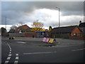
There are currently over 7.5m images from over14,400 individuals and you can help contribute to the project by visiting https://www.geograph.org.uk
Image Map
Images are licensed for reuse under creativecommons.org/licenses/by-sa/2.0
Notes
- Clicking on the map will re-center to the selected point.
- The higher the marker number, the further away the image location is from the centre of the postcode.
Image Listing (43 Images Found)
Images are licensed for reuse under creativecommons.org/licenses/by-sa/2.0
Image
Details
Distance
1
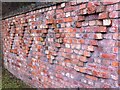
Brick wall dated 2002
Brick wall on Woodshires Road, Longford, by the railway bridge, the brickwork of which can be seen in the background.
Image: © A J Paxton
Taken: 23 Aug 2020
0.10 miles
2
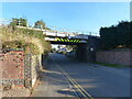
Railway bridge, Bedworth, Coventry
The sign on the bridge describes it as "Bridge CNN/26 Synall Road/Woodshires Road at Bedworth"
Image: © Ruth Sharville
Taken: 23 Sep 2021
0.10 miles
3
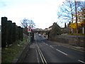
Railway bridge over Woodshires Road, Longford
The bridge carrying the Coventry to Nuneaton railway line over Woodshires Road gives a clearance of 13ft, so the bus route that passes under it is always operated with single deck buses.
Image: © Richard Vince
Taken: 10 Nov 2012
0.11 miles
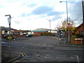
4
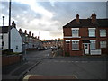
Grindle Road, Longford
A residential street in Longford, lined with terraced housing, seen from the bus turning circle at the west end of Oban Road (see Image). Similar housing is visible on Sydnall Road (right foreground).
Image: © Richard Vince
Taken: 10 Nov 2012
0.13 miles
5
Oban Road turning circle, Longford (2)
The bus turning circle at the west end of Oban Road is no longer necessary for turning buses, as the route that serves Oban Road (effectively a shortworking of route 20 from Coventry city centre to Bedworth) returns to the main road via Woodshires Road (out of frame to the left). However, with the bus stop still in the turning circle, it effectively functions as a large layby. Buses exit the turning circle by turning right into Sydnall Road (foreground), using a short length of it to reach Woodshires Road.
Image: © Richard Vince
Taken: 10 Nov 2012
0.13 miles
6
Oban Road turning circle, Longford (1)
The bus turning circle at the west end of Oban Road is no longer necessary for turning buses, as the route that serves Oban Road (effectively a shortworking of route 20 from Coventry city centre to Bedworth) returns to the main road via Woodshires Road (out of frame to the left). However, with the bus stop still in the turning circle, it effectively functions as a large layby. This is a largely residential part of the city, despite the industrial premises visible on Oban Road.
Image: © Richard Vince
Taken: 10 Nov 2012
0.14 miles
7
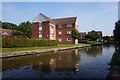
Flats on Grindle Road
Overlooking Coventry Canal.
Image: © Ian S
Taken: 27 Aug 2019
0.15 miles
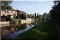
8
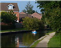
Towpath and houses along the Coventry Canal
Image: © Mat Fascione
Taken: 11 Sep 2014
0.16 miles
10
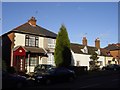
Cottages Wilsons Lane, Longford
Cottages on Wilson's Lane, Longford, once a tiny hamlet but now just an outpost in Coventry's urban sprawl but the back gardens still have unrestricted views of the countryside.
Image: © Sue Adair
Taken: 3 Feb 2003
0.17 miles