IMAGES TAKEN NEAR TO
Crown Green, COVENTRY, CV6 6FA
Introduction
This page details the photographs taken nearby to Crown Green, CV6 6FA by members of the Geograph project.
The Geograph project started in 2005 with the aim of publishing, organising and preserving representative images for every square kilometre of Great Britain, Ireland and the Isle of Man.

There are currently over 7.5m images from over14,400 individuals and you can help contribute to the project by visiting https://www.geograph.org.uk
Image Map
Images are licensed for reuse under creativecommons.org/licenses/by-sa/2.0
Notes
- Clicking on the map will re-center to the selected point.
- The higher the marker number, the further away the image location is from the centre of the postcode.
Image Listing (24 Images Found)
Images are licensed for reuse under creativecommons.org/licenses/by-sa/2.0
Image
Details
Distance
3
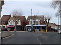
Coventry-Lythalls Lane
Fish and Chip shop at the corner of Bedlam Lane.
Image: © Ian Rob
Taken: 4 Jun 2011
0.10 miles
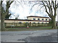
4
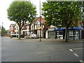
Coventry-Cherry Tree Sports & Social Club
At the junction of Lythalls Lane and Bedlam Lane.
Image: © Ian Rob
Taken: 4 Jun 2011
0.10 miles
5
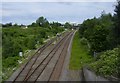
Coventry-Holbrook Way
Looking down on to the Coventry-Nuneaton Railway.The spur off to the left ran to the former Keresley Colliery, and now goes to the Prologis Park Terminal. But it has not been used for several years. The Ricoh Arena and the Lythalls Lane bridge can be seen in the distance.
Image: © Ian Rob
Taken: 4 Jun 2011
0.11 miles
6
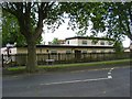
The Cherry Tree public house
On Lythalls Lane.
Image: © JThomas
Taken: 4 Mar 2017
0.11 miles
7
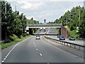
Coventry-Phoenix Way
Looking towards the Ricoh Arena from the Lythalls Lane bridge.
Image: © Ian Rob
Taken: 4 Jun 2011
0.11 miles
8
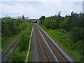
Coventry to Nuneaton Line
Looking down on to the Coventry-Nuneaton Railway.The spur off to the left ran to the former Keresley Colliery. The Ricoh Arena can be seen in the distance.
Image: © Ian Rob
Taken: 4 Jun 2011
0.12 miles
9
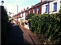
Booth's Fields, Foleshill
This 'off-road' terrace of houses, fronting onto a footpath, dates from the early 20th century; the OS Six Inch 1888-1913 Series map https://maps.nls.uk/geo/explore/side-by-side/#zoom=16&lat=52.44003&lon=-1.49592&layers=6&right=osm shows a footpath, only partly built up and without these houses, in Little Heath on the northern edge of Coventry.
The path today forms Booth's Fields and its eastern continuation, an alley called Bacon's Yard; they connect Lythalls Lane and Foleshill Road, and are now deep in the built-up area of the city.
Image: © A J Paxton
Taken: 14 Jul 2022
0.13 miles
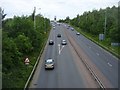
10
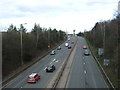
Phoenix Way (A444)
Looking north east from the bridge on Lythalls Lane.
Image: © JThomas
Taken: 4 Mar 2017
0.14 miles