IMAGES TAKEN NEAR TO
Elmsdale Avenue, COVENTRY, CV6 6ET
Introduction
This page details the photographs taken nearby to Elmsdale Avenue, CV6 6ET by members of the Geograph project.
The Geograph project started in 2005 with the aim of publishing, organising and preserving representative images for every square kilometre of Great Britain, Ireland and the Isle of Man.

There are currently over 7.5m images from over14,400 individuals and you can help contribute to the project by visiting https://www.geograph.org.uk
Image Map
Images are licensed for reuse under creativecommons.org/licenses/by-sa/2.0
Notes
- Clicking on the map will re-center to the selected point.
- The higher the marker number, the further away the image location is from the centre of the postcode.
Image Listing (29 Images Found)
Images are licensed for reuse under creativecommons.org/licenses/by-sa/2.0
Image
Details
Distance
1
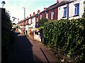
Booth's Fields, Foleshill
This 'off-road' terrace of houses, fronting onto a footpath, dates from the early 20th century; the OS Six Inch 1888-1913 Series map https://maps.nls.uk/geo/explore/side-by-side/#zoom=16&lat=52.44003&lon=-1.49592&layers=6&right=osm shows a footpath, only partly built up and without these houses, in Little Heath on the northern edge of Coventry.
The path today forms Booth's Fields and its eastern continuation, an alley called Bacon's Yard; they connect Lythalls Lane and Foleshill Road, and are now deep in the built-up area of the city.
Image: © A J Paxton
Taken: 14 Jul 2022
0.05 miles
2
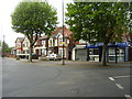
The Cherry Tree public house
On Lythalls Lane.
Image: © JThomas
Taken: 4 Mar 2017
0.09 miles
3
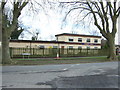
Coventry-Cherry Tree Sports & Social Club
At the junction of Lythalls Lane and Bedlam Lane.
Image: © Ian Rob
Taken: 4 Jun 2011
0.09 miles
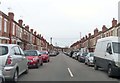
5
Coventry-Lythalls Lane
Fish and Chip shop at the corner of Bedlam Lane.
Image: © Ian Rob
Taken: 4 Jun 2011
0.11 miles
6
King George's Avenue heading to Lythalls Lane
Image: © Steve Daniels
Taken: 23 Mar 2019
0.12 miles
7
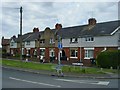
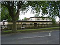
Coventry-Bedlam Lane
Terraced housing dating from 1915.
Image: © Ian Rob
Taken: 4 Jun 2011
0.12 miles
8
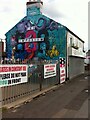
Mural of antique dealer and sandwich bar, Foleshill Road, Coventry
The underwater-themed mural and model dragons announce the 888 Emporium antique and salvage business, situated in a yard behind the Triple Ate Batch Bar, both at 888 Foleshill Road. The mural is signed by Off Key. The blue is Coventry sky blue; on the chimney is painted, Sky Blue Heaven, Eighty-Seven, referring to the year, 1987, when Coventry City won the FA Cup.
Image: © A J Paxton
Taken: 31 Jul 2021
0.14 miles
9
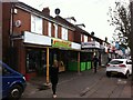
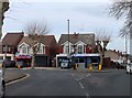
Danielo, what do we have here ?
A row of shops on Foleshill Road, Coventry. First, a Romanian food shop, 'Danielo, ce avem noi aici? Un minimarket costele'. Then more food shops interspersed with barbers, then a bright mural on a gable end announcing an antique and salvage business. The cars badly parked on the pavement are characteristic of Foleshill Road, too.
Image: © A J Paxton
Taken: 31 Jul 2021
0.15 miles
10
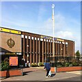
Ramgarhia Gurdwara, Foleshill Road, Coventry
The Ramgarhia Gurdwara is a Sikh temple (gurdwara) on a prominent site at 1103 Foleshill Road, further out of town than most other Coventry gurdwaras. Its website is here http://ramgarhiagurdwara.com/ , but has nothing to say about its history. It was founded in 1965, according to the Victoria County History of Warwickshire, Vol 8, pp396-397 https://www.british-history.ac.uk/vch/warks/vol8/pp396-397 . A brief TV news clip of the opening of the new building in 1969 can be seen here https://www.macearchive.org/films/midlands-news-07111969-opening-sikh-temple-coventry . The new structure shown in the news report is attached to a row of terraced houses, which have since been replaced as the gurdwara has been extended.
Image: © A J Paxton
Taken: 9 Oct 2021
0.15 miles