IMAGES TAKEN NEAR TO
Midland Road, COVENTRY, CV6 5SL
Introduction
This page details the photographs taken nearby to Midland Road, CV6 5SL by members of the Geograph project.
The Geograph project started in 2005 with the aim of publishing, organising and preserving representative images for every square kilometre of Great Britain, Ireland and the Isle of Man.

There are currently over 7.5m images from over14,400 individuals and you can help contribute to the project by visiting https://www.geograph.org.uk
Image Map (Loading...)


Getting Data...Please wait
Leaflet Map data © OpenStreetMap
Images are licensed for reuse under creativecommons.org/licenses/by-sa/2.0
Notes
- Clicking on the map will re-center to the selected point.
- The higher the marker number, the further away the image location is from the centre of the postcode.
Image Listing (124 Images Found)
Images are licensed for reuse under creativecommons.org/licenses/by-sa/2.0
Image
Details
Distance
1
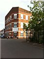
Mosque on Smith Street, Coventry
Mosque in a converted factory building at the corner of Smith Street and Midland Road, part of a small area of streets between Red Lane, the former ordnance factory and the canal. It may have been built as part of the ordnance works, since it is marked as part of the factory site on this plan: https://www.gracesguide.co.uk/File:ImV103-p547.jpg The mosque is called the Shah Jalal Jame Masjid and serves the local Bangladeshi community.
Image: © A J Paxton
Taken: 14 Jun 2021
0.06 miles
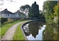
2

Coventry : Coventry Canal
The Coventry Canal is a navigable narrow canal in the Midlands of England.
Image: © Lewis Clarke
Taken: 25 Sep 2021
0.06 miles
3
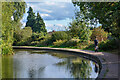
Coventry : Coventry Canal
The Coventry Canal is a navigable narrow canal in the Midlands of England.
Image: © Lewis Clarke
Taken: 25 Sep 2021
0.07 miles
5
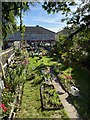
![A stroll along the Coventry Canal to Hawkesbury Junction [7]](https://s3.geograph.org.uk/geophotos/07/12/11/7121123_cf2fa9ff_120x120.jpg)
A stroll along the Coventry Canal to Hawkesbury Junction [7]
A rear garden full of kitsch belonging to a house in The Chantries.
The narrow canal was built to connect the city of Coventry with the Trent & Mersey Canal, some 38 miles distant, to exploit the Warwickshire coalfields. Construction of the canal took 20 years before it was complete in 1769. The canal between the basin in Coventry and Hawkesbury junction was made a conservation area in 2012.
Image: © Michael Dibb
Taken: 23 Sep 2021
0.08 miles
6
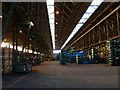
Inside the Ordnance Works
Difficult to photograph. Trying to give an idea of the size of the building. Now used for storing Jaguar car parts
Image: © Kevin Croucher
Taken: 13 Jun 2005
0.09 miles
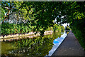
7
Towpath along the Coventry Canal
The semi detached houses are on the Chantries.
Image: © Mat Fascione
Taken: 11 Sep 2014
0.09 miles
8
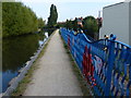
Fence along the towpath of the Coventry Canal
The fence separates the end of Freehold Street from the towpath.
Image: © Mat Fascione
Taken: 11 Sep 2014
0.10 miles
9
Coventry : Coventry Canal
The Coventry Canal is a navigable narrow canal in the Midlands of England.
Image: © Lewis Clarke
Taken: 25 Sep 2021
0.10 miles
10
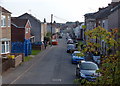
Freehold Street in Coventry
Looking south from the towpath of the Coventry Canal.
Image: © Mat Fascione
Taken: 11 Sep 2014
0.10 miles