IMAGES TAKEN NEAR TO
Central City Industrial Estate, Red Lane, COVENTRY, CV6 5RY
Introduction
This page details the photographs taken nearby to Central City Industrial Estate, Red Lane, CV6 5RY by members of the Geograph project.
The Geograph project started in 2005 with the aim of publishing, organising and preserving representative images for every square kilometre of Great Britain, Ireland and the Isle of Man.

There are currently over 7.5m images from over14,400 individuals and you can help contribute to the project by visiting https://www.geograph.org.uk
Image Map
Images are licensed for reuse under creativecommons.org/licenses/by-sa/2.0
Notes
- Clicking on the map will re-center to the selected point.
- The higher the marker number, the further away the image location is from the centre of the postcode.
Image Listing (104 Images Found)
Images are licensed for reuse under creativecommons.org/licenses/by-sa/2.0
Image
Details
Distance
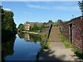
1
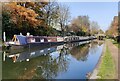
Narrowboats moored along the Coventry Canal
Image: © Mat Fascione
Taken: 7 Nov 2020
0.01 miles
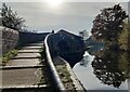
2
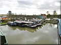
Stoke Heath Basin
Moorings off Coventry Canal.
Image: © Mike Faherty
Taken: 19 Feb 2016
0.02 miles
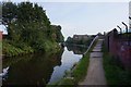
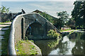
3
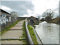
Stoke Heath, Bridge No 4a
At the entrance to Stoke Heath Basin, on Coventry Canal.
Image: © Mike Faherty
Taken: 19 Feb 2016
0.02 miles
5
Towpath bridge, Coventry Canal
Carrying the towpath over the entrance to Stoke Heath Wharf https://www.geograph.org.uk/photo/6971330 , built in the mid 19th century.
Image: © Alan Murray-Rust
Taken: 23 Sep 2021
0.02 miles
6
![A stroll along the Coventry Canal to Hawkesbury Junction [11]](https://s3.geograph.org.uk/geophotos/07/12/11/7121131_be49a469_120x120.jpg)
A stroll along the Coventry Canal to Hawkesbury Junction [11]
The towpath is carried over the entrance to Stoke Heath Wharf, a small canal basin. See Image and Image
The narrow canal was built to connect the city of Coventry with the Trent & Mersey Canal, some 38 miles distant, to exploit the Warwickshire coalfields. Construction of the canal took 20 years before it was complete in 1769. The canal between the basin in Coventry and Hawkesbury junction was made a conservation area in 2012.
Image: © Michael Dibb
Taken: 23 Sep 2021
0.02 miles
7
Coventry Canal at Stoke Heath, Coventry
The bridge carries the towpath across the entrance to the Stoke Heath Basin.
Image: © Mat Fascione
Taken: 7 Nov 2020
0.02 miles
8
![A stroll along the Coventry Canal to Hawkesbury Junction [13]](https://s1.geograph.org.uk/geophotos/07/12/11/7121133_23693c13_120x120.jpg)
A stroll along the Coventry Canal to Hawkesbury Junction [13]
The bridge carries the towpath over the entrance to the Stoke Heath Wharf basin. See also Image and Image
The narrow canal was built to connect the city of Coventry with the Trent & Mersey Canal, some 38 miles distant, to exploit the Warwickshire coalfields. Construction of the canal took 20 years before it was complete in 1769. The canal between the basin in Coventry and Hawkesbury junction was made a conservation area in 2012.
Image: © Michael Dibb
Taken: 23 Sep 2021
0.02 miles
9
Footbridge, Stoke Heath Basin
Bridge carrying the Coventry Canal towpath over the entrance to Stoke Heath Basin.
Image: © Ian Capper
Taken: 23 Sep 2021
0.02 miles
10
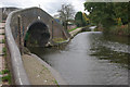
Coventry Canal, Stoke Heath
The towpath bridge gives access to Stoke Heath Basin.
Image: © Stephen McKay
Taken: 19 Oct 2008
0.02 miles